When the tide decides
How three island communities are shaping a floating solar future.
What energy means on Tamparang Island
By Agung Iswadi, Jodi Setiawan, Iriani, Mary Ann Franco, and Leuserina Garniati.
In Rannu, Katinting, and Biyawasa, three sub-villages on Tamparang Island, energy is not an abstract concept. Following sunsets, it is the difference between “we can” and “we can’t”. It is productivity, safety, learning time and the ability to dream a little further ahead than tomorrow.
When people hear floating solar, they often picture panels and pontoons. However, on Tamparang, the story starts much earlier, with community rhythms, sea space and trust. That is where the project began to shift from data to a journey.
From a systems perspective, what becomes clear is that energy access cannot be treated purely as a technical gap. It is deeply intertwined with livelihood security, gendered household and community roles, mobility patterns, and the informal structures that shape daily decision-making.
Step one: listen to daily life, then look at the data
Before we talk about solutions, we need to understand when energy is actually needed, and how that demand changes across households and villages.
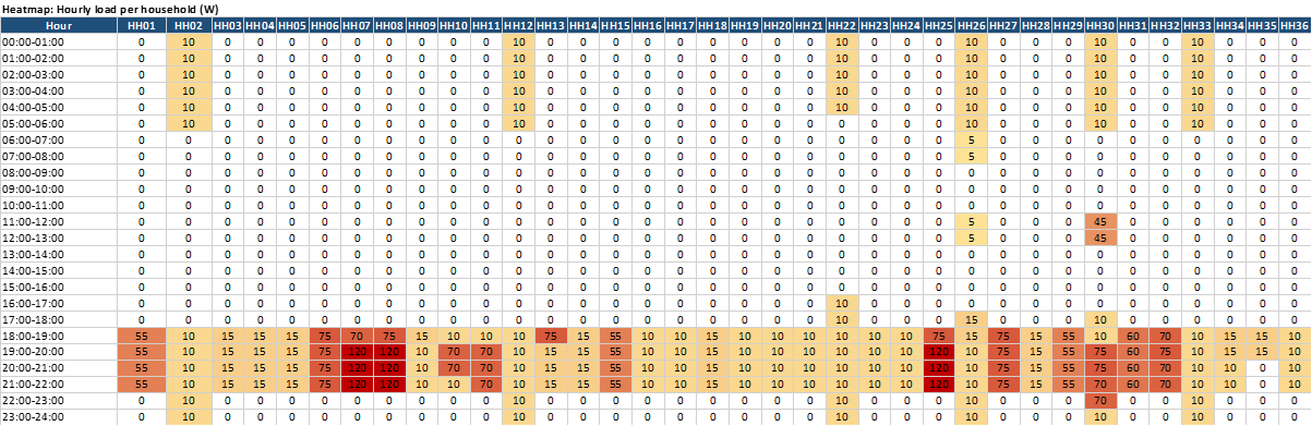
Along with household surveys by POWERE team members, we mapped daily energy demand–supply patterns into simple heatmaps. At first glance, they look technical, but they are really a portrait of everyday life: quiet time, working hours and the “busy” moments when households converge on similar needs (lighting, charging, cooking, and family time).
Most activity clusters in predictable windows, especially when people return from work, seaweed handling, or household tasks.
- The “red zones” are not just peak load, they are peak living: when lighting, social time and device charging often overlap.
- Every community looks similar at a distance, but not up close. Some households show consistent demand; others appear intermittent, reflecting differences in livelihoods, equipment ownership, or access constraints.
The pattern and nuances also signal differentiated vulnerabilities. Households with less demand are not simply lower users but these could relate to decision-making dynamics and prioritisation of productive versus consumptive loads.
These visuals were not meant to impress. They were meant to help us answer a more human question: “If floating solar is going to work here, what does it really need to support it?”
That question pushed us forward into the next stage: going from “how people use energy” to “what the sea will allow.”
Step two: permission first, because the sea is a lived-in place
In Tamparang, the sea is not empty space. It is a place of livelihoods, especially seaweed farming and daily mobility. So, before any marine survey, the most important step is not deploying equipment. It is asking permission and listening carefully.
Through community discussions and coordination with seaweed farmers and local leaders, we sought consent for hydro-oceanography survey activities and gathered essential local inputs about:
- where seaweed lines and working zones are concentrated
- the boat routes that must stay open
- safe access points and areas to avoid.
Early consent processes also help surface power dynamics within communities, identifying whose voices are actually heard, whose livelihoods matters most and who are most exposed to spatial change, as well as where informal tenures or usages rights may not be formally documented.
This is not “nice to have.” It is how we ensure any future energy infrastructure fits the realities of the people who live there.
Step three: place-based knowledge shapes the field plan
Satellite maps can not show everything that matters. Communities can!
Place-based knowledge helped translate the marine environment into practical guidance, where movement happens, where activities cluster, and which areas carry sensitivity because of livelihood dependence or daily use.
When communities help shape the plan, feasibility work becomes more than technical validation, it becomes a shared decision-making.
This co-development approach also helps reduce any potential for downstream friction, where spending time in participatory spatial decision making ease permitting, potential grievance handling and implementation stages.
A technically “perfect” site that disrupts livelihoods is not perfect at all.
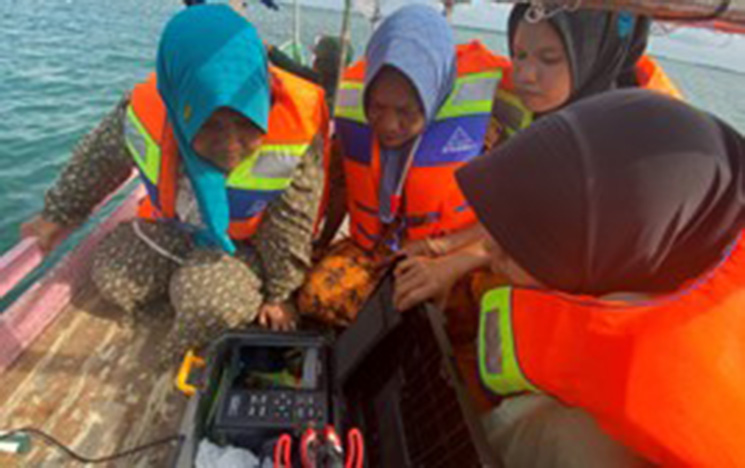
Step four: reading the water, so designs can belong here
With permission and local guidance, we moved into hydro-oceanography survey work to understand the physical and environmental conditions that floating solar must live with every day:
- water depth and seabed profile (bathymetry)
- tides and tidal currents
- seabed sediment conditions
- basic water quality parameters.
This is how we translate the sea into design inputs, especially for mooring/anchoring concepts, structural considerations and operational practicality.
The purpose is simple: design should follow the environment, not fight it.
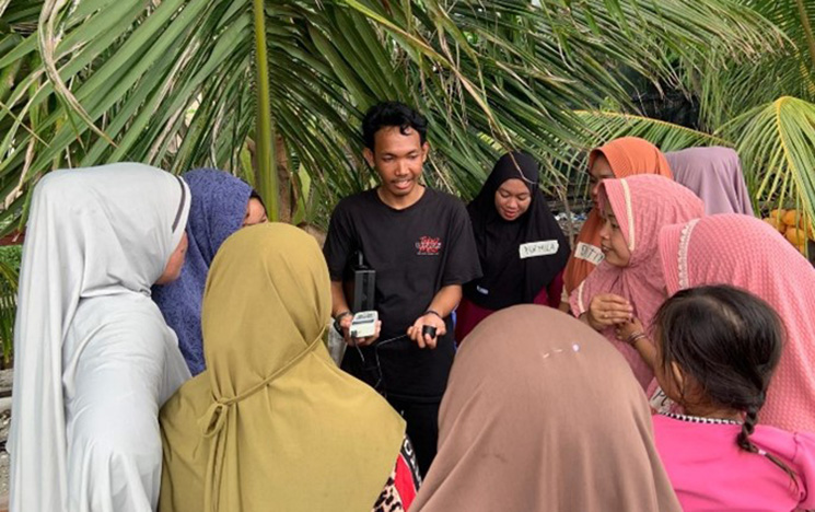
Step five: action learning – capacity building in real time
One of the most meaningful parts of the work was not a meeting room session. It was learning that happened during fieldwork: people observing, asking questions and connecting why measurements matter to real project decisions.
This is action learning, practical, inclusive, and grounded led by Diah Irawaty and Runavia Mulyasari with women in the selected villages. It helps build local confidence and ownership, so the project is not something done to communities, but shaped with them.
What this phase achieved
This stage of work brought together the pieces that make floating solar feasible and responsible:
- evidence of energy needs through village-level demand-supply patterns
- community consent and guidance as a foundation for all marine activities
- field-based understanding of sea conditions that will shape energy system design options
- ongoing engagement and action learning to support local capability and long-term ownership.
Sustained capacity building will be critical in determining whether these evolve from project sites into locally stewarded energy systems. Future action learning may benefit from structured pathways linking technical exposure with longer-term skills development, local maintenance roles and community-based energy governance models.
What comes next
Floating solar feasibility is not a single “yes/no” decision. It is a careful narrowing of options: site by site, constraint by constraint, with the community always in the room.
From here, the data collected will continue to be analysed and combined with social and environmental considerations to support:
- final site selection
- energy system design options that match local sea conditions and community needs and aspirations
- impact assessment planning that takes local livelihoods seriously
- continuous in-bound and out-bound knowledge transfer and learning.
This is how “technical work” becomes a shared journey: one tide, one conversation, one dataset at a time.
Because in Tamparang, the strongest projects are not only technically sound, they are community-led, environmentally aware and designed to fit the tide, not fight it.