Forecasting for drought in Kenya
A collaboration between University of Sussex researchers, Kenyan national agencies and non-governmental organisations aims to improve drought predictions through the use of machine learning techniques to analyse satellite-based Earth observations.
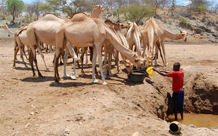
Rain typically falls between February and June in the semi-arid regions of East Africa, but when the rains fail, come late, or end early, the lack of vegetation leaves livestock with little to eat — a formula for famine. Kenya’s northern arid and semi-arid regions, which make up 80 percent of the country, often suffer from unpredictable rainfall and droughts, frequently leaving around 3 million of the country’s 13.6 million inhabitants in crisis, unsure of how to feed their families or livestock.
“Nowadays, droughts have become much more frequent. Before you’d get them every five to ten years. Now it’s often down to every two years,” said Maurine Ambani, Project Manager for Climate Research at the Kenyan Red Cross.
“Waiting for a disaster to happen”
“Currently everybody waits for a disaster to happen, but it has been proven that being better prepared – anticipating these events – is economically better and saves human lives and livelihoods,” said Pedram Rowhani, Senior Lecturer in Geography at the University of Sussex. “But it requires a shift in attitudes and the way systems work.”
Early warning systems generally currently focus on forecasting rainfall to anticipate impending droughts. Many Kenyan and UK agencies, including the UK Met Office, currently work with rainfall data to carry out the forecasting. However, it is becoming increasingly clear that forecast products need to move beyond rainfall.
During discussions with researchers from the Department of Geography at the University of Sussex, the Kenya Red Cross suggested that it would better to instead focus on measuring a direct indicator of the impact of rainfall: the state of pasture and crops in Kenya’s arid and semi-arid lands. “When you have some information about the vegetation, it takes you a step closer to having a forecast about the potential impact of the drought,” said Ambani.
The Regional Centre for Mapping of Resources for International Development (RCMRD), a research inter-governmental organisation based in Nairobi, Kenya has been collecting its own real time Moderate Resolution Imaging Spectroradiometer (MODIS) NASA satellite data since 2014 through its receiver station. But the RCMRD knew that it wasn’t using all of the data to its full potential. “We didn’t have all the data processing tools to use the MODIS receiver optimally, as we had hoped”, said Denis Macharia, Weather and climate lead at the RCMRD.
Seb Oliver, Professor of Astrophysics at the University of Sussex has previously led teams with responsibility for data processing and scientific analysis of space missions, including the European Space Agency Herschel Space Observatory, the largest telescope ever flown in space. The Sussex geographers and the Kenyan agencies knew Oliver’s team had the skills necessary to help. “Because of Sussex’s expertise in machine learning, we thought this was an opportunity for a strong partnership,” said Macharia. They began to work together to come up with some solutions.
How the new system works
The measure they began to analyse is called the Vegetation Condition Index (VCI). Put crudely, this index indicates an anomaly in the greenness of vegetation by measuring how green the vegetation is at a specific point in the season compared to how green it was at that point in the past. To determine how ‘green’ a patch of land is, scientists measure the difference between the different wavelength bands in images taken by satellites orbiting the Earth. Sunlight is made up of a spectrum of different wavelengths, with certain wavelengths absorbed, and others reflected. Chlorophyll in plant leaves strongly absorbs visible light, but the cell structure of leaves strongly reflects near-infrared light, which is not visible to human sight. Vegetation with more reflected radiation in near-infrared wavelengths is likely to contain forest, while if there is very little difference, then the vegetation is likely to be desert or grassland.
All regions form relatively predictable patterns caused by rainfall and the seasons. In order to develop a pattern for this region, the team began to track the VCI data from MODIS and Landsat satellite data, using linear autoregression and Gaussian Processes, a modern machine or statistical analysis technique looking at time series to make projections. Both of the models were able to predict droughts four weeks in advance with a hit rate of around 89% and a false alarm rate of around 4%. They could forecast six weeks ahead with an accuracy of 81%.
“The forecasts are actually very precise and that means that people on the ground are potentially willing to take action as a result of the forecasts,” said Professor Seb Oliver. “Because it is accurate, it is easier for people to make that mental shift.”
While having an accurate forecasting model is important, the wider aim of the project is to build the skills and capacity of the RCMRD and other East African technical government agencies so they can use the software models developed by the Sussex team to carry out the drought forecasting themselves. “We’re trying to give power to the different agencies on the ground,” said Rowhani. Ultimately the Sussex team want to democratise drought forecasting information so that anyone with a mobile phone and some data can access it.
Through the collaboration with Sussex, the RCMRD aims to soon be able to provide vegetation forecasts six weeks in advance, in addition to the rainfall forecasts that it is currently providing around 15 days in advance. The RCMRD aims to provide this data to a technical group that coordinates drought responses in Kenya, made up of non-governmental organisations, such as the Kenyan Red Cross, and Kenyan ministries, such as the National Drought Management Authority, a Kenyan government organisation which aims to mitigate drought emergencies.
While the pilot is just within Kenya, it is eventually hoped that the forecasting techniques could benefit other countries. “Because these are scaleable techniques, we’re hoping that we can expand to other countries, such as Ethiopia and Uganda. And the information isn’t just for range lands, it could be useful for crop farmers also,” said Macharia.
Using the forecasting model to improve people’s lives
Ultimately, these forecasts could help save lives and reduce the number of children living with malnutrition during a drought. “When vegetation is sparse and livestock starts to die, women and children are badly affected, as they use the milk every day. You start to see malnutrition set in, and their income reduces,” said Ambani.
Humanitarian organisations in Kenya generally focus on one of two approaches to support vulnerable families in drought-hit regions, such as families with no parents, or single parent households. They provide families with fodder to feed their livestock or with cash transfers, so families can buy food and other necessities. Having six weeks’ warning gives humanitarian organisations more time to identify and register vulnerable and poor families, to organise fodder shipments and delivery and to carry out local market research on staple food prices in order to set the correct price for cash transfers.
“Having forecasts six weeks before gives us a window period to plan,” said Ambani. “There are always millions affected. I am really hoping that this is going to help us connect the dots from the forecast to actually taking targeted action so that the impact of the drought on families is reduced,” said Ambani.
References: Barrett, Adam B, Duivenvoorden, Steven, Salakpi, Edward E, Muthoka, James M, Mwangi, John, Oliver, Seb and Rowhani, Pedram (2020) Forecasting vegetation condition for drought early warning systems in pastoral communities in Kenya. Remote Sensing of Environment. ISSN 0034-4257
Contact us
Research development enquiries:
researchexternal@sussex.ac.uk
Research impact enquiries:
rqi@sussex.ac.uk
Research governance enquiries:
rgoffice@sussex.ac.uk
Doctoral study enquiries:
doctoralschool@sussex.ac.uk
Undergraduate research enquiries:
undergraduate-research@sussex.ac.uk
General press enquiries:
press@sussex.ac.uk