
Thai Coast: Coastal Vulnerability, Resilience and Adaptation in Thailand
The goal of the Thai-coast project is to improve scientific understanding of the vulnerability of Thailand's shoreline and coastal communities to hydro-meteorological hazards, including storms, floods and coastal erosion, under future climate change scenarios. In Thailand the problems of coastal erosion and flooding require immediate solutions because they affect more than 11 million people living in coastal zone communities (17% of the country's population). The Department of Marine and Coastal Resources (DMCR), in the Thai Government's Ministry of Natural Resources and Environment, has calculated that each year erosion causes Thailand to lose 30 km2 of coastal land. The Office of Natural Resources and Environmental Policy and Planning predicts that sea level will rise by 1 metre in the next 40 -100 years, impacting at least 3,200 km2 of coastal land, through erosion and flooding, at a potential financial cost to Thailand of 3 billion baht [almost £70 million] over that time period. The Thai-coast project addresses the urgent need to enhance the resilience and adaptation potential of coastal communities, applying scientific research to inform more robust and cost-effective governance and institutional arrangements.
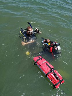
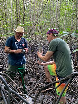
Sample collection, Krabi Province, Thailand
The Thai-coast project aims to (i) establish causal links between climate change, coastal erosion and flooding; (ii) use this information to assess the interaction of natural and social processes in order to (iii) enhance coastal community resilience and future sustainability. The project focuses on two study areas, Nakhon Si Thammarat province and Krabi province, selected on the basis of DMCR coastal erosion data and with contrasting natural and socio-economic characteristics. The Thai-coast project uses a multidisciplinary approach, integrating climate science, geomorphology, socio-economics, health and wellbeing science and geo-information technology to improve understanding of hydro-meteorological hazard occurrence, their physical and socioeconomic, health and wellbeing impacts on Thailand's coastal zone and the ways in which governance and institutional arrangements mitigate their impact. We will examine future scenarios of climate change hydrometeorology, coastal landform and land use change scenarios and assess and model impacts (coastal erosion, rivermarine flooding, impacts on health and well-being), as well as population and community's adaptation, and socioeconomics scenarios for sustainable development goals (sustainable cities, health-related quality of life and well-being, good governance). Our collaborative team of natural and social scientists, from UK, US and Thai research institutions, have complementary, cutting-edge expertise and will work closely with Thai Government and UK and Thai industry partners to ensure that results are policy and practice-relevant.
Thai-coast research will benefit government and policy makers, who need to plan for potential impacts caused by climate change and develop resilient strategies to deal with their impacts on natural-social systems. It will provide a link with government agencies for business/industry interests in the coastal zone of Thailand in tourism, aquaculture and associated industry and business, to assess their needs and help improve their understanding of coastal resilience in their strategic investments and management. The wider public, who inhabit Thailand's coastal communities either permanently or temporarily for work or leisure, will benefit through the advanced knowledge and awareness of identified problems and learning processes to address them. The results of the Thai-coast project will benefit coastal communities more broadly, in all Thai coastal provinces, through its contribution to more robust, cost effective, governance and institutional arrangements.
Peacehaven & Telscombe Cliffs Project
Coastal cliff recession represents a significant risk to both people and infrastructure. It is important that we are able to effectively monitor these environments to inform future decisions regarding the management of the coastline and to forecast future erosion rates, in order to support the resiliency of the UK’s coastal communities.
Approximately 3,300 km of the coastline of England and Wales is formed of sea cliffs, with only 6% currently defended. Within the UK, the Environment Agency and the Department for the Environment, Food and Rural Affairs (DEFRA) have a statutory responsibility to mitigate coastal hazards through shoreline management plans. These plans rely on reliable estimates of coastal erosion and its consequences over the next 100 years.
However, in many cases, shoreline management plans are based on coastal erosion data derived from historical maps and aerial photographs. Positional errors in these maps and photographs (the difference between location as represented in a map or a photograph and the actual location of the coastline) are often comparable to erosion rates, which makes producing reliable information about the rate of coastal cliff recession difficult.
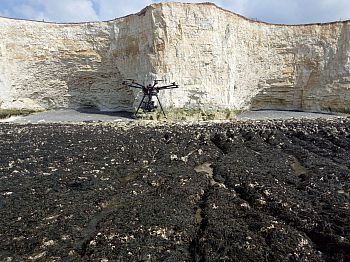 DJI S1000 Octocoptor drone
Geomorphologists at the University of Sussex, who study the evolution of the coastline, hare conducting research involving new technologies to achieve high-precision monitoring of sea cliffs. This has allowed for much more accurate estimates of erosion and for more robust predictions of coastal change. High-precision monitoring undertaken at Telscombe, East Sussex has produced the first quantitative estimate of coastal cliff recession that incorporates climate change predictions.
The use of Unmanned Aerial Vehicles (commonly known as drones) to undertake this high precision monitoring offers a relatively low-cost method for generating more accurate erosion data for long sections of the coast, which can then be used to inform the management of any risks posed by future cliff recession more effectively. We recommend that DEFRA and the Environment Agency explore the potential to make increased use of these new technologies to facilitate more accurate monitoring of coastal erosion across the UK.
 Telscombe - erosion along the cliff face