
Rising Climate Change Impacts: Innovative Strategies to Adapt Coastal Systems to High End Scenarios (RISES-AM)
European Union, University of Sussex with University of Southampton.
PI Sussex Richard Tol
The general objective of RISES-AM- is assessing the cross-sectoral and economy-wide impacts and vulnerability of coastal systems at local, regional and global scales, across the full range of representative concentration pathways (RCPs) and shared socio-economic pathways (SSPs). This will be achieved by integrating a series of specific objectives pertaining to four different areas of knowledge:
- Adaptive management
- Decisions under uncertainty
- Dynamic (transient) analyses
- Dynamic (transient) analyses
- Coastal zone sustainability
Establishing a Predictive Process Response Model for Sea Cliff Risk Management at Brighton
EPSRC iCase studentship, University of Sussex and CH2M HillCo-PI Roger Moore and John Barlow
The primary aim (A1) of the study is to quantify the relaxation curve of sea cliffs defended with seawalls in the proximity of Brighton Marina. In order to accomplish this, we have set the following objectives:
O1: Determine the historical rates of retreat for defended and undefended chalk cliffs of similar characteristics and exposure in the area.
O2: Determine the critical angle of stability for chalk cliffs of differing material properties and structure.
O3: Estimate the time of relaxation from defence installation to the establishment of equilibrium angle in O2 (above).
Our secondary aim (A2) is to establish the effectiveness of current mitigation approaches. This will be accomplished through:
O4: Quantifying the erosional mass flux (rock fall) from cliff faces along the undercliff pathway.
O5: Monitoring of cliff face environmental conditions using thermal and optical cameras mounted in Brighton Marina.
Measuring active layer depth to develop predictive models of mixed sediment beach response to wave energies
NERC Case studentship, University of Sussex with Havant Borough Council and University of Southampton.
PI Cherith Moses, co-I David Picksley, Havant Borough Council, David Sear, University of Southampton.
Mixed sediment beaches (MSBs) with sediment sizes ranging over three orders of magnitude are an increasingly important defence against coastal flooding and erosion. Understanding their dynamics is relevant to the management of more than one third of the shoreline of England and Wales and almost all of the heavily populated SE coast of England. Some 70% of the latter's shoreline has a Hold the Line policy under which marine dredged aggregate (recharge), which is increasingly expensive, is added to maintain adequate beach volumes. Beaches lose sediment via longshore and offshore transport whose accurate quantification is critical to calculating recharge amounts needed for effective beach management. Industry does this using sediment transport modelling which depends on reliable input data and modelling assumptions. Tracer experiments to calculate longshore transport rates, require three measurements: distance travelled by the tracers' centre of mass or volume; thickness of the moving sediment layer (the active layer); width over which transport occurs. On MSBs the latter two are often estimated and considered homogenous across and alongshore. Beach response to waves is controlled largely by permeability and that of MSB is highly variable. Recharging reduces it by introducing a higher proportion of fine sand. Limited field studies of MSB hydraulic conductivity focus on sediment movement mechanisms and profile changes, neglecting active layer depth.
We will combine fluvial and coastal sediment transport theories, using innovative sediment tracer technologies, to understand active layer behaviour to improve model input data and to inform MSB management policy and practice.
Reconstructing the failure chronology of the St Catherine’s Point Landslide Complex using cosmogenic [10Be] and [26Al]
NERC funding provided for 6 samples through the Cosmogenic Isotope Analysis Facility valued at £7 740.
PI: John Barlow; Co-I: Roger Moore
The aim of this pilot study is to reconstruct the failure chronology of the landslide model for the St Catherine’s Point landslide complex. In order to achieve this, we have set the following objectives: (O1) Date the initiation of failure along the current back scarp of the landslide complex using in situ [10Be] and [26Al] measured from samples of chert from the Upper Greensand formation. (O2) Establish the exposure age of chert from the Upper Greensand located in the landward block in order to establish the exposure age of the pre-failure scarp face. (O3) Establish whether the exposure age of detached blocks located on the seaward block is contemporaneous with those identified in O2 (above).
 The EU, Interreg III funded Beaches At Risk (BAR) project
BAR is a transnational project that highlights the importance of effective beach management for coastal defence, dune rehabilitation, tourism and biodiversity conservation. Researchers have been working to identify beaches suffering greatest erosion on both the Channel coasts, assess their susceptibility to predicted sea level rise and increased storminess, identify nature conservation sites that would be lost or damaged as a result, and identify the risks for coastal management. The project team consists of geomorphologists and geologists at the Université de Rouen, Université de Caen and Université de Littoral (Dunkerque) and ecologists at East Sussex County Council and Kent Wildlife Trust working together with geomorphologists at the University of Sussex.
Project Leader: Cherith Moses
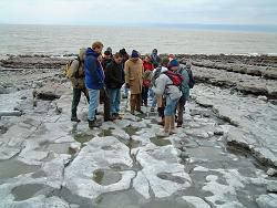
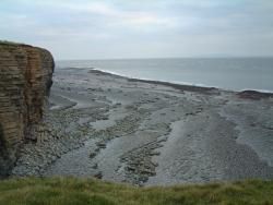
The DEFRA funded Understanding and Predicting Beach Morphological Change Associated with the Erosion of Cohesive Shore Platforms
Cohesive shore platforms are developed in relatively non-resistant material and the irreversible erosion of these landforms plays a large part in controlling the functioning of the wider coastal system. In order to manage this coastal system most effectively, an improved understanding is required amongst coastal scientists and managers of the erosion and weathering processes governing the behaviour of these landforms, and also of their interactions with beaches and backing sea cliffs. This research project has aimed to improve our technical understanding of the roles of the different parameters and processes that contribute to the down-wearing of cohesive shore platforms through:
- a detailed review of existing literature;
- innovative field work campaigns at two contrasting platform-beach sites in the UK;
- laboratory analyses of collected samples; and
- a series of numerical model tests.
The improved scientific knowledge gained from the study has been translated into preliminary 'best practice' guidance for coastal managers. The research team includes Posford Haskoning Ltd., University of Sussex, British Geological Society and University of Newcastle.
Project Leader: Royal Haskoning Ltd.
 The EU, MAST III funded ESPED project
The group has worked collaboratively with coastal researchers in France, Portugal, Sweden, Spain and Britain to study the evolution of rocky coasts. The ESPED project has brought together geologists, ecologists, geographers and engineers to further scientific understanding of the processes that control shore platform downwearing and cliff recession.
Project Leader: Rendel Williams
The EU, Interreg II funded BERM project
Understanding the potential sustainability of beaches on the Channel coasts is of vital importance for effective coastal management in the region. In the BERM project we teamed up with geographers and geologists at the University of Rouen and coastal managers on both sides of the Channel to carry out pioneering work on the origin, evolution and sustainability of the Channel coast beaches of East Sussex, Seine Maritime and Somme.
Project Leader: Cherith Moses
The Environment Agency funded STONE project
Sediment transport in estuaries is poorly understood, yet is of considerable importance for effective management of the coastal zone. Together with the Environment Agency and Compass Hydrographic Services Ltd. we have monitored sediment transfer across the Ouse-Newhaven Estuary over a three year period to enhance understanding of sediment dynamics.
Project Leaders: Andy Cundy, Cherith Moses, Rendel Williams
The EU, Interreg III funded, Rive Manche Estuary Watch (RIMEW) project
The project examined the potential for the sustainable management of contaminated sediments from the Seine, Medway and Ouse estuaries. An extensive sampling programme was undertaken of both surface sediments and deep sedimentary cores in all three estuaries and the samples analysed for a variety of contaminants both organic and inorganic. The research team involved partners from the Universities of Rouen, Le Havre, Littoral and Lille in France and Sussex, Brighton, Greenwich and Queen Mary College in the UK.
Project Leader: Andy Cundy
The DEFRA funded Erosion of Cohesive Shorelines project
This project was a scoping study (to current best practice) of the processes associated with the erosion of cohesive shore platforms and interactions with the sediment budget in order to identify the research and development needs; define a research project to address the gaps in our understanding and provide detailed guidance to best practice regarding the management of these coastlines; and provide preliminary advice regarding the management of these coastlines. The research team included Posford Haskoning Ltd., University of Sussex, British Geological Society and University of Newcastle.
Project Leader: Royal Haskoning Ltd.