Maps
Our campus already has an amazing 38% of land set aside for nature and now we’re committing to setting aside more. View our maps to see how this could look for our campus and give us your feedback.
To take part in this consultation, open the survey, and fill it out in conjunction with the maps provided below.
You can use this accompanying key [PDF 8.58KB] when viewing each map.
Map one
This baseline map shows the current land use scenario on campus. It demonstrates which areas are currently set aside for nature.
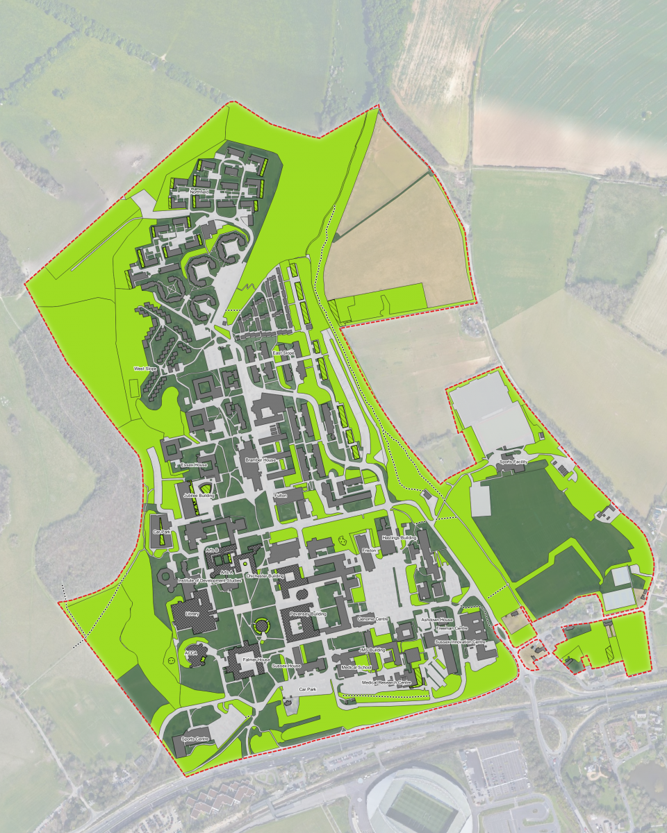
Download map one to see a more detailed version of the plans [PDF 1.3MB].
You can see an accessible version of the location descriptions for map one below.
- Location description
Location descriptions for map one Landmark Description of areas set aside for nature Category Reference Outer campus Large area of chalk grassland in the North West corner of campus, to the West of Northfield and North East of the Jubilee woodland Low management BL1 Outer campus Large woodland area to the East of Lewes Court and Northfield Low management BL2 Outer campus Large grassland area to the North of Northfield which includes the Forest Food Garden Low management BL3 Outer campus Large woodland area to the East of Northfield and Lewes Court, North of Brighthelm Low management BL4 Northfield Green roof on Northfield Block 1 Passive Rewilding BL5 Northfield Green roof on Northfield Block 2 Passive Rewilding BL6 Northfield Green roof on Northfield Block 3 Passive Rewilding BL7 Northfield Green roof on Northfield Block 8 Passive Rewilding BL8 Northfield Green roof on Northfield Block 9 Passive Rewilding BL9 Northfield Green roof on Northfield Block 10 Passive Rewilding BL10 Northfield Green roof on Northfield Block 11 Passive Rewilding BL11 Northfield Green roof on Northfield Block 12 Passive Rewilding BL12 Northfield Green roof on Northfield Block 13 Passive Rewilding BL13 Northfield Green roof on Northfield Block 14 Passive Rewilding BL14 Northfield Green roof on Northfield Block 15 Passive Rewilding BL15 Northfield Green roof on Northfield Block 16 Passive Rewilding BL16 Northfield Green roof on Northfield Block 17 Passive Rewilding BL17 Northfield Green roof on Northfield Block 19 Passive Rewilding BL18 Lewes Court Lawn to the North of Lewes Court Block 3 Low management BL19 Lewes Court Lawn to the North of Lewes Court Block 4 Low management BL20 Brighthelm Sloped area between the staircases to the East of Brighthelm, leading up to East Slope Camber 1-12 Low management BL21 Outer campus Rectangular field area between Brighthelm and Ridge road, between two large fields Low management BL22 Outer campus Small area to the East of Brighthelm, directly to the West of zone 23 Passive Rewilding BL23 Outer campus Area of woodland surrounding boundary walk path on East of Campus, running from Pavilion Road, across the East of all of East Slope, to North East of Brighthelm Low management BL24 Outer campus Hedgerow surrounding the tenanted field on the North-east of campus Low management BL25 Outer campus Area of woodland surrounding boundary walk path on East of Campus, running discontinuously from Pavilion Road southwards to the East entrance of campus from the A27 Low management BL26 Swanborough Rectangular area in courtyard to the South of Swanborough Block 3
Low management BL27 Swanborough Rectangular area in courtyard to the South of Swanborough Block 2 Low management BL28 Swanborough Sloped area to the East of Swanborough Blocks 2 and 1, spanning round to the North of Fulton Low management BL29 Fulton Sloped wooded area to the East of Fulton, reaching down to Boiler House Hill Low management BL30 Fulton Banks of wildflowers line the path round the corner of Refectory Road and Boiler House Hill Low management BL31 East Slope Green roof on Camber 1-3 Passive Rewilding BL32 East Slope Green roof on Camber 4-7 Passive Rewilding BL33 East Slope Green roof on Camber 8-12 Passive Rewilding BL34 East Slope Green roof on Camber 13-15 Passive Rewilding BL35 East Slope Green roof on Camber 16-20 Passive Rewilding BL36 East Slope Green roof on Camber 21-25 Passive Rewilding BL37 East Slope Green roof on Camber 26-28 Passive Rewilding BL38 East Slope Green roof on Camber 29-31 Passive Rewilding BL39 East Slope Meadow area to the East of the Camber buildings 1-3, 4-7, 8-12, which is continuous up to the boundary woodland Low management BL40 East Slope Meadow areas between Camber flats 12-31 and the Ridge car park Low management BL41 East Slope Green verge between the Ridge carpark and the Boundary woodland (REF) Low management BL42 East Slope Sloped area to the West of 1-16 Lullington buildings Low management BL43 East Slope Green area to the East of 17-32 Lullington buildings Low management BL44 East Slope Sloped areas to the East of the 57-96 Lullington buildings, creating a network of areas curving round the North and East of the Bodiam buildings where East Slope Road meets Boiler House HillGreen area to the East of 17-32 Lullington buildings Low management BL45 Falmer Sports Complex Scrub and grass verge surrounding the artificial sports pitches to the North of the Sports Centre buildings Low management BL46 Falmer Sports Complex Wooded area either side of Pavilion road Low management BL47 Falmer Sports Complex Wooded area to the North of the playing fields, South of the Sports Centre Buildings, South West of Ridge Road Low management BL48 Falmer Sports Complex Wooded area to the East of the playing fields, South of the Sports Centre Buildings, running South West alongside Ridge Road Low management BL49 Falmer Sports Complex Wooded area to the East of the Eastern Ring Road, to the West of the playing fields Low management BL50 Falmer Sports Complex Hedge/Treeline running through the middle of the playing fields Low management BL51 Falmer Sports Complex Treeline bordering the South and West of the tennis courts Low management BL52 Shawcross Area of woodland to the North of shawcross, between the building and Arts Road BL53 Arundel Large area of woodland running along the South of Boiler house hill, covering the North and East of Richmond, surrounding Friston, and to the North of Hastings, stopping at Estates Road. This contains the woodland walk and a pond. BL54 Hastings Large area of woodland running along the South of Boiler house hill, covering the North and East of Richmond, surrounding Friston, and to the North of Hastings, stopping at Estates Road. This contains the woodland walk and a pond.
BL55 Friston Large area of woodland running along the South of Boiler house hill, covering the North and East of Richmond, surrounding Friston, and to the North of Hastings, stopping at Estates Road. This contains the woodland walk and a pond. BL56 Hastings Area of woodland to the East of Hastings, which spans the Hastings building to Boiler House Hill, with a footpath running through it towards the John Clifford West building. BL57 Arts A Rectangular pond in the courtyard between Arts A and Arts B Waterbody BL58 Arts B Rectangular pond in the courtyard between Arts A and Arts B Waterbody BL59 Arts A Round pond in to the South of Arts A Waterbody BL60 Arts A Triangle of wildflower meadow outside of Arts Piazza, on the East side of Arts A BL61 Chichester Two small rectangles of low management outside the entrance of Chichester, to the West of building BL62 Chichester Rectangle of low management to the East of Chichester along North South Road BL63 CISC Three triangles of low management around the ramp down to the CISC centre, in the north end of the Knights Gate Road carpark BL64 CISC Area of low management to the South East of the Knights Gate Road car park, spanning the length of the road connecting Science Park Road and Knights Gate Road BL65 Freeman Small area of low management against the North end of the Freeman Centre, spanning the width of the building only and reaching up to the footpath not the road BL66 Thermo-fluid Mechanics Research Centre Two mid-sized areas along the east side of Science Car Park, spanning from Science Park Road to the Trafford Centre BL67 Pevensey III Mid-sized area to west of Science Car Park, against the east of Pevensey III BL68 JMS Area of woodland to North-East of JMS building, in the south west corner of the Science Car Park BL69 JMS Area of grassland between JMS and BSMS, to North of biology road BL70 JMS Areas along the north of biology road, running around the South-east side of JMS and the medical school BL71 CRPC Areas of woodland surrounding the north, east, and south side of the CRPC, the East of JMS BL72 BSMS Research Centre Area of Passive Rewilding to the East and South-east of the BSMS Research Centre BL73 Southern Ring Road Woodland running alongside the entire Southern Ring Road leading from JMS to Sussex Innovation Centre, down to the A27 and across to the East entrance to campus from the A27 slip road BL74 Norwich House Bank to the South of Norwich House Low management BL75 Norwich House Grassy area to the West of Norwich House, surrounding North end of car park Low management BL76 Jubilee Green roof on Jubilee building Passive Rewilding BL77 Jubilee Green roof on Jubilee lecture theatre Passive Rewilding BL78 Jubilee Grassy area to the West of Jubilee building Low management BL79 Jubilee Car Park Centre areas in multi-storey car park Passive Rewilding BL80 Jubilee Car Park Bank to the West of car park Low management BL81 Jubilee Car Park Area to the South of car park Low management BL82 Jubilee Car Park Area to the South East of car park Low management BL83 Outer campus Boundary woodland on the West of campus, running to the West of IDS, the Library and the ACCA Low management BL84 Outer campus Field to the West of the boundary woodland on the West of campus, bordering Stanmer Park Low management BL85 ACCA Area surrounding dew pond to the West of the ACCA Low management BL86 ACCA Dew pond to the West of the ACCA Low management BL87 Library Bank on West side of library Low management BL88 ACCA Bank surrounding the West, North West and North sides of the ACCA Low management BL89 ACCA Pond on South East side of the ACCA Low management BL90 ACCA Woodland to the South of the ACCA, directly North of the bus stop near the Sports Centre Low management BL91 Sports Centre Small strip of woodland running along the West side of the road near the concrete University of Sussex sign, between the playing fields at the edge of Stanmer Park and the sports centre Low management BL92 Sports Centre Woodland to the South, South West and West of the Sports Centre Low management BL93 Sports Centre Hedge and woodland between the Sports Centre car park and the road and path that intersect at the level crossing at the entrance to campus Low management BL94 Campus entrance Sparsely wooded area to the West of the path and cycle path that lead towards the campus from the underpass, South of the Sports Centre car park Low management BL95 Campus entrance Flower bed bordering the East of the path and cycle path that lead towards the campus from the underpass Low management BL96 Campus entrance Sparsely wooded area to the East of the path and cycle path that lead towards the campus from the underpass Low management BL97 Campus entrance Small patch of ground on the Southern quarter of the intersection of the path that leads to campus from the underpass and the bike path that crosses it Low management BL98 Sussex House Wildflower area on the East side of the larger patch of green area that sits between Sussex House and Falmer House Low management BL99 Sussex House Green area running alongside the West side of the Sussex House courtyard Low management BL100 Meeting House Three ponds surrounding the Meeting House Low management BL101 Outer campus (South East) Field on the South Eastern point of campus, bordered by Mill Street, Ridge Road and Middle Street Low management BL102 Outer campus (South East) Small wooded area North of the terraced houses on Middle Street Low management BL103 Outer campus (South East) Field area North of the Swan Inn, South of Mill Street Low management BL104
Map two
This map shows an example of potential land use if the percentage of campus land set aside for nature was increased to 40%.
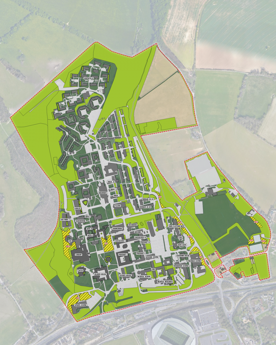
Download map two to see a more detailed version of the plans [PDF 1.2MB].
You can see an accessible version of the location descriptions for map two below.
- Location description
Location descriptions for map two Landmark Description of areas set aside for nature Reference IDS Grassy area surrounding IDS on the North, West and South sides, extending South behind the Library IDS1 Library Square Partially wooded area on the East side of Library Square, between the Meeting House, Chichester I and Arts A LS1 Sports Centre Grassy areas directly to the North of the Sports Centre, South of University Way road SC1 Freeman Centre Partially wooded grassy area bordering the Freeman Centre on the East and North sides FC1 CISC Partially wooded area to the East of the car park at CISC and Aisin Seiki CISC1 John Clifford West Wooded area directly to the East of John Clifford West JCW1 East Slope Bank on the North West quarter of the intersection of East Slope Road and Boiler House Hill ES1 Falmer Sports Complex Grass space between Easternmost football pitch and surrounding woodland FSC1 Falmer Sports Complex Triangular grass space between the two Northernmost tennis courts and the playing fields, on the West side of the tennis courts FSC2 Falmer Sports Complex Grass space to the West of the tennis courts, bordering Ridge Road FSC3
Map three
This map shows an example of potential land use if the percentage of campus land set aside for nature was increased to 45%.
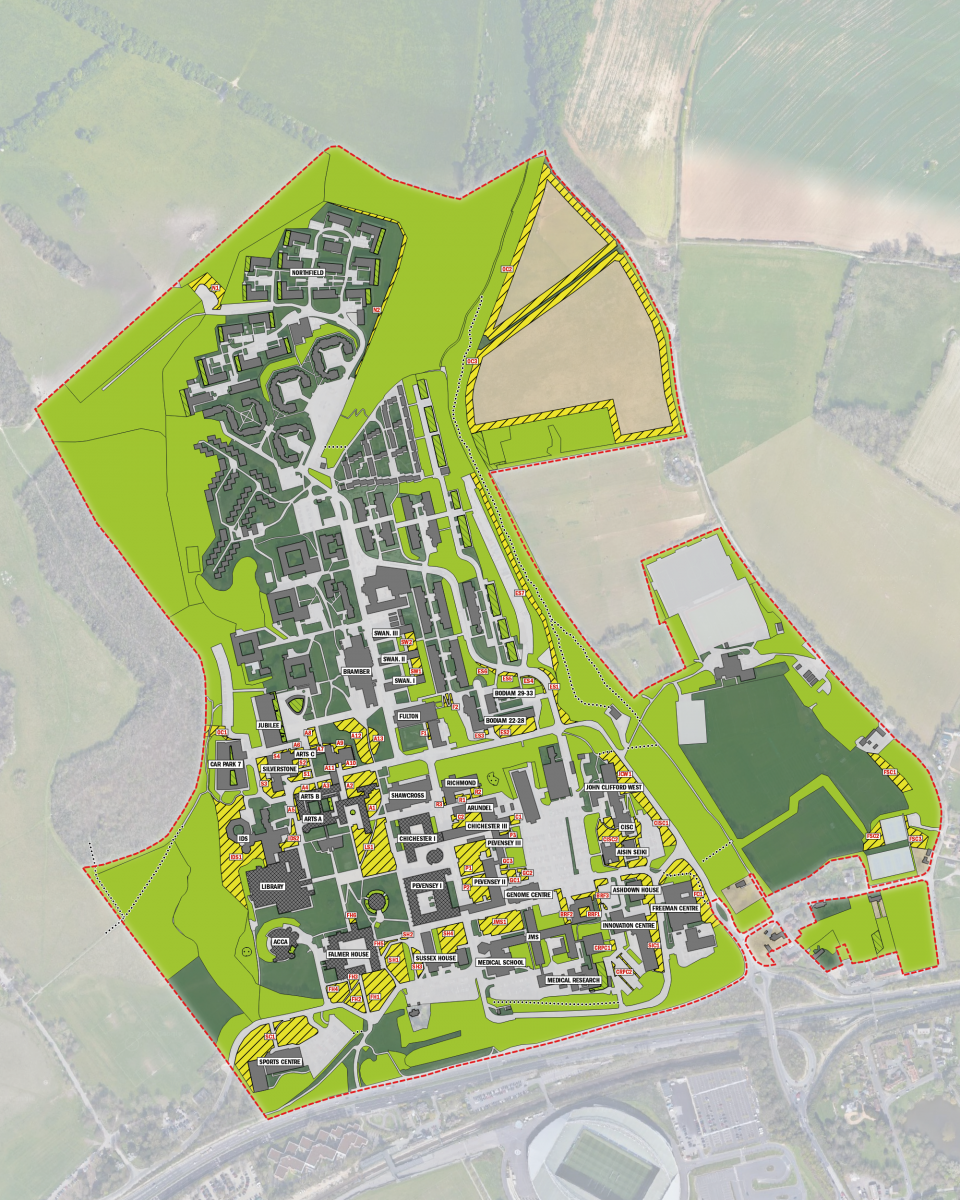
Download map three to see a more detailed version of the plans [PDF 1.3MB].
You can see an accessible version of the location descriptions for map three below.
- Location description
Location descriptions for map three Landmark Description of areas set aside for nature Reference IDS Grassy area surrounding IDS on the North, West and South sides, extending South behind the Library IDS1 Library Square Partially wooded area on the East side of Library Square, between the Meeting House, Chichester I and Arts A LS1 Sports Centre Grassy areas directly to the North of the Sports Centre, South of University Way road SC1 Freeman Centre Partially wooded grassy area bordering the Freeman Centre on the East and North sides FC1 CISC Partially wooded area to the East of the car park at CISC and Aisin Seiki CISC1 John Clifford West Wooded area directly to the East of John Clifford West JCW1 East Slope Bank on the North West quarter of the intersection of East Slope Road and Boiler House Hill ES1 Falmer Sports Complex Grass space between Easternmost football pitch and surrounding woodland FSC1 Falmer Sports Complex Triangular grass space between the two Northernmost tennis courts and the playing fields, on the West side of the tennis courts FSC2 Falmer Sports Complex Grass space to the West of the tennis courts, bordering Ridge Road FSC3 Falmer House Green, partially wooded area directly to the East of the path leading into the South entrance of the Falmer House courtyard FH1 Falmer House Green, partially wooded area directly to the West of the path leading into the South entrance of the Falmer House courtyard FH2 Falmer House Small green area bordered by the main path to the South entrance of the Falmer House courtyard, the diagonal path leading from the direction of the bus stop, and Falmer House, on the South side of Falmer House FH3 Falmer House Green area to South of Falmer House, to the West of the main entrance path, on the corner of University Way and Gardner Centre Road FH4 Falmer House Small triangular green area in between Falmer House and Sussex House, directly to the East of the SU shop FH5 Sussex House Partially wooded area to the East of the Wildflower area, directly between Falmer House and Sussex House SH1 Sussex House Very small eliptical shaped grassy area West of the bottom of the steps between Pevensey I and Sussex House SH2 Falmer House Small square patch of green space directly to the East of the path that leads from the Falmer House courtyard into Library square, directly to the North of Falmer House FH6 Sussex House Grassy courtyard area on the North East side of Sussex House SH3 JMS Green, partially wooded area to the North of JMS, between JMS and the stepped pathway that runs alongside Pevensey II JMS1 Pevensey Northernmost partially wooded green area on banks between Pevensey I and Pevensey II P1 Pevensey Southernmost partially wooded green area on banks between Pevensey I and Pevensey II P2 Genome Centre Westernmost green area directly North of the Genome Centre GC1 Genome Centre Easternmost green area directly North of the Genome Centre GC2 Genome Centre Small green space directly to the North of the bottom of the sloped path that leads from the car park to Pevensey II GC3 Pevensey Small green space directly to the South of the bottom of the steps which lead from the car park to Pevensey III P3 Chichester Square green space between Friston and Chichester III, to the North of the steps which lead from the car park to Pevensey III C1 Chichester Green courtyard area between Arundel, Chichester II and Chichester III C2 Richmond Westernmost green area on the South side of Richmond, directly between Richmond and Arundel R1 Richmond Easternmost green area on the South side of Richmond, directly between Richmond and Arundel R2 Richmond Small green bank on the West side of Richmond, near the entrance to the building R3 Biomedical Research Facility Square roof space on Biomedical Research Facility BRF1 Biomedical Research Facility Green space directly to the West of the Biomedical Research Facility BRF2 Biomedical Research Facility Grass area to the North of the Biomedical Research Facility that runs between Car Park 1 and the Ashdown House car park BRF3 CRPC Small rectangular patch of green space to the East of the building, bordering the North West side of Car Park 2 CRPC1 CRPC Green banks in centre of Car Park 2 that divide the parking spaces CRPC2 Sussex Innovation Centre Large green bank that runs down the East side of the Sussex Innovation Centre and Ashdown House, alongside the Southern Ring Road SIC1 CISC Green spaces inbetween the CISC building, Aisin Seiki and the Thermo-fluid Mechanics Research Centre CISC1 Arts Green space bordering the East of Arts A, opposite the Shawcross entrance A1 Arts Green bank to the East of Arts B, to the West of the Arts Road bridge A2 Arts Easternmost green bank to the North of Arts B in the Dhaba courtyard, to the South of Arts Road A3 Arts Westernmost green bank to the North of Arts B in the Dhaba courtyard, to the South of Arts Road A4 Arts Grass verge bordering the West of Arts B A5 Silverstone Grass bank in the Dhaba courtyard on the North side of Arts Road, South of the steps leading into Silverstone S1 Silverstone Grass area in the Dhaba courtyard on the North side of Arts Road, North of the steps leading into Silverstone S2 Silverstone Verge bordering the West side of Silverstone opposite the multistorey car park, on the East side of Arts Road S3 IDS Grass bank to the East of IDS, running alongside the path leading to the IDS café IDS2 Outer campus Verge between the North side of the multistorey car park and upper arts car park 7a OC1 Arts Grass area on the North side of Arts C, next to the stairs leading to the multistorey car park, on the West side of the Northern entrance to Arts C A6 Silverstone Grass area on the North side of Silverstone, next to the stairs leading to the multistorey car park S4 Arts Grass area on the North side of Arts C, on the East side of the Northern entrance to Arts C A7 Arts Raised grass area on the North side of Arts C, south of the Jubilee lecture theatre A8 Arts Triangular grass area on the North side of the Global Studies Resource Centre A9 Arts Grass area between the South side of the Global Studies Resource Centre and Arts Road A10 Arts Small area on the left of the Arts Road entrance to the school of Global Studies A11 Arts Large green space on the West side of the path leading from the Arts Road bridge towards Bramber House A12 Arts Large green space on the East side of the path leading from the Arts Road bridge towards Bramber House A13 Swanborough Rectangular green space on the East side of the courtyard between Swanborough I and Swanborough II SW1 Swanborough Rectangular green space on the East side of the courtyard between Swanborough II and Swanborough III SW2 Fulton Small verge on the West side of the boiler house F1 Fulton Green space surrounding the accessible rampway on the North East corner of Fulton F2 East Slope Large green space on the South side of Bodiam 20-28, to the East of the East Slope Reception entrance ES1 East Slope Small square patch of vegetation directly to the West of the steps leading to the East Slope reception ES2 East Slope Easternmost grass bank on the South side of East Slope Road, North of Bodiam 34-36 ES3 East Slope Middle grass bank on the South side of East Slope Road, North of Bodiam 29-33 ES4 East Slope Westernmost grass bank on the South side of East Slope Road, North of Bodiam 16-19 ES5 East Slope Long grass verge running alongside the boundary walk on the East side of East Slope ES6 Outer campus Triangular area to the West of Northfield Block 16 and 17 OC2 Outer campus Border of smaller Northernmost field on the North West of campus OC3 Outer campus Border of larger Southermost field on the North West of campus OC4 Northfield Grass border running alongside the woodland bordering Northfield on the East and North East sides N1
Map four
This map shows an example of potential land use if the percentage of campus land set aside for nature was increased to 50%.
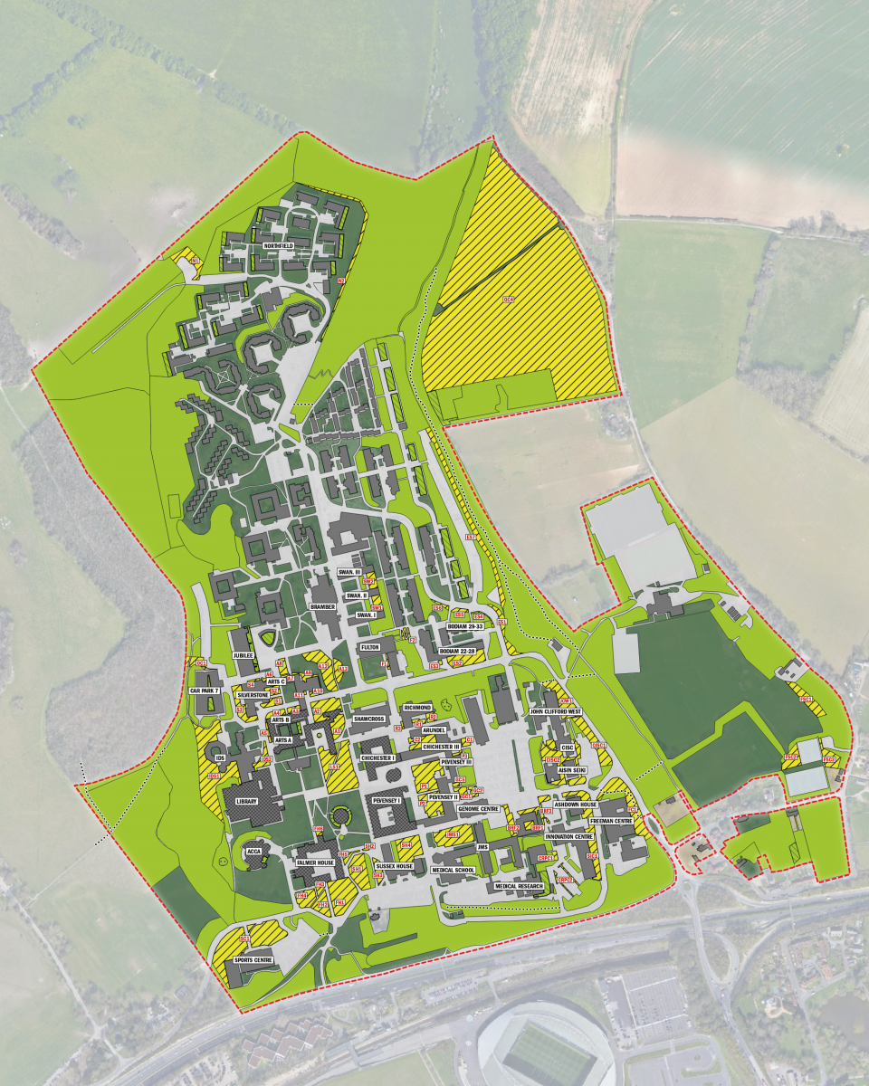
Download map four to see a more detailed version of the plans [PDF 1.4MB].
You can see an accessible version of the location descriptions for map four below.
- Location description
Location descriptions for map four Landmark Description of areas set aside for nature Reference IDS Grassy area surrounding IDS on the North, West and South sides, extending South behind the Library IDS1 Library Square Partially wooded area on the East side of Library Square, between the Meeting House, Chichester I and Arts A LS1 Sports Centre Grassy areas directly to the North of the Sports Centre, South of University Way road SC1 Freeman Centre Partially wooded grassy area bordering the Freeman Centre on the East and North sides FC1 CISC Partially wooded area to the East of the car park at CISC and Aisin Seiki CISC1 John Clifford West Wooded area directly to the East of John Clifford West JCW1 East Slope Bank on the North West quarter of the intersection of East Slope Road and Boiler House Hill ES1 Falmer Sports Complex Grass space between Easternmost football pitch and surrounding woodland FSC1 Falmer Sports Complex Triangular grass space between the two Northernmost tennis courts and the playing fields, on the West side of the tennis courts FSC2 Falmer Sports Complex Grass space to the West of the tennis courts, bordering Ridge Road FSC3 Falmer House Green, partially wooded area directly to the East of the path leading into the South entrance of the Falmer House courtyard FH1 Falmer House Green, partially wooded area directly to the West of the path leading into the South entrance of the Falmer House courtyard FH2 Falmer House Small green area bordered by the main path to the South entrance of the Falmer House courtyard, the diagonal path leading from the direction of the bus stop, and Falmer House, on the South side of Falmer House FH3 Falmer House Green area to South of Falmer House, to the West of the main entrance path, on the corner of University Way and Gardner Centre Road FH4 Falmer House Small triangular green area in between Falmer House and Sussex House, directly to the East of the SU shop FH5 Sussex House Partially wooded area to the East of the Wildflower area, directly between Falmer House and Sussex House SH1 Sussex House Very small eliptical shaped grassy area West of the bottom of the steps between Pevensey I and Sussex House SH2 Falmer House Small square patch of green space directly to the East of the path that leads from the Falmer House courtyard into Library square, directly to the North of Falmer House FH6 Sussex House Grassy courtyard area on the North East side of Sussex House SH3 JMS Green, partially wooded area to the North of JMS, between JMS and the stepped pathway that runs alongside Pevensey II JMS1 Pevensey Northernmost partially wooded green area on banks between Pevensey I and Pevensey II P1 Pevensey Southernmost partially wooded green area on banks between Pevensey I and Pevensey II P2 Genome Centre Westernmost green area directly North of the Genome Centre GC1 Genome Centre Easternmost green area directly North of the Genome Centre GC2 Genome Centre Small green space directly to the North of the bottom of the sloped path that leads from the car park to Pevensey II GC3 Pevensey Small green space directly to the South of the bottom of the steps which lead from the car park to Pevensey III P3 Chichester Square green space between Friston and Chichester III, to the North of the steps which lead from the car park to Pevensey III C1 Chichester Green courtyard area between Arundel, Chichester II and Chichester III C2 Richmond Westernmost green area on the South side of Richmond, directly between Richmond and Arundel R1 Richmond Easternmost green area on the South side of Richmond, directly between Richmond and Arundel R2 Richmond Small green bank on the West side of Richmond, near the entrance to the building R3 Biomedical Research Facility Square roof space on Biomedical Research Facility BRF1 Biomedical Research Facility Green space directly to the West of the Biomedical Research Facility BRF2 Biomedical Research Facility Grass area to the North of the Biomedical Research Facility that runs between Car Park 1 and the Ashdown House car park BRF3 CRPC Small rectangular patch of green space to the East of the building, bordering the North West side of Car Park 2 CRPC1 CRPC Green banks in centre of Car Park 2 that divide the parking spaces CRPC2 Sussex Innovation Centre Large green bank that runs down the East side of the Sussex Innovation Centre and Ashdown House, alongside the Southern Ring Road SIC1 CISC Green spaces inbetween the CISC building, Aisin Seiki and the Thermo-fluid Mechanics Research Centre CISC1 Arts Green space bordering the East of Arts A, opposite the Shawcross entrance A1 Arts Green bank to the East of Arts B, to the West of the Arts Road bridge A2 Arts Easternmost green bank to the North of Arts B in the Dhaba courtyard, to the South of Arts Road A3 Arts Westernmost green bank to the North of Arts B in the Dhaba courtyard, to the South of Arts Road A4 Arts Grass verge bordering the West of Arts B A5 Silverstone Grass bank in the Dhaba courtyard on the North side of Arts Road, South of the steps leading into Silverstone S1 Silverstone Grass area in the Dhaba courtyard on the North side of Arts Road, North of the steps leading into Silverstone S2 Silverstone Verge bordering the West side of Silverstone opposite the multistorey car park, on the East side of Arts Road S3 IDS Grass bank to the East of IDS, running alongside the path leading to the IDS café IDS2 Outer campus Verge between the North side of the multistorey car park and upper arts car park 7a OC1 Arts Grass area on the North side of Arts C, next to the stairs leading to the multistorey car park, on the West side of the Northern entrance to Arts C A6 Silverstone Grass area on the North side of Silverstone, next to the stairs leading to the multistorey car park S4 Arts Grass area on the North side of Arts C, on the East side of the Northern entrance to Arts C A7 Arts Raised grass area on the North side of Arts C, south of the Jubilee lecture theatre A8 Arts Triangular grass area on the North side of the Global Studies Resource Centre A9 Arts Grass area between the South side of the Global Studies Resource Centre and Arts Road A10 Arts Small area on the left of the Arts Road entrance to the school of Global Studies A11 Arts Large green space on the West side of the path leading from the Arts Road bridge towards Bramber House A12 Arts Large green space on the East side of the path leading from the Arts Road bridge towards Bramber House A13 Swanborough Rectangular green space on the East side of the courtyard between Swanborough I and Swanborough II SW1 Swanborough Rectangular green space on the East side of the courtyard between Swanborough II and Swanborough III SW2 Fulton Small verge on the West side of the boiler house F1 Fulton Green space surrounding the accessible rampway on the North East corner of Fulton F2 East Slope Large green space on the South side of Bodiam 20-28, to the East of the East Slope Reception entrance ES1 East Slope Small square patch of vegetation directly to the West of the steps leading to the East Slope reception ES2 East Slope Easternmost grass bank on the South side of East Slope Road, North of Bodiam 34-36 ES3 East Slope Middle grass bank on the South side of East Slope Road, North of Bodiam 29-33 ES4 East Slope Westernmost grass bank on the South side of East Slope Road, North of Bodiam 16-19 ES5 East Slope Long grass verge running alongside the boundary walk on the East side of East Slope ES6 Outer campus Triangular area to the West of Northfield Block 16 and 17 OC2 Outer campus Border of smaller Northernmost field on the North West of campus OC3 Outer campus Border of larger Southermost field on the North West of campus OC4 Northfield Grass border running alongside the woodland bordering Northfield on the East and North East sides N1 Outer campus The entirety of the two fields on the North East of campus OC4