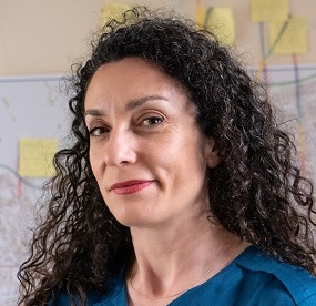
BAR logo
Home
Organisations & Project team
Project area
Leaflets, reports & publications
Education packs
Beach changes
Wildlife and coastal habitats
Newsletter archive
Contact e-mail:
bar-project@sussex.ac.uk
Public events
Data
Links
Copyright & disclaimer

1920s Maps

The download links will only work from January 2007 when server space is avaialable.

The file name includes information about the map location and survey date; the first letter and number indicates map sheet name followed by the publication year and the year(s) when the map was revised (rev) or partly revised (part-rev) though there is no indication as to what parts have or have not been revised.


g-66se-1931rev1928-29.TIF
g-66sw-1938rev1929-30.TIF
g-77ne-1931-revised1929.TIF
g-78-ne-1929-east.TIF
g-78-ne-1929-west.TIF
g-78nw-1928-east-level-revised1909.TIF
g-78nw-1928-west-lev-revised1909.TIF
g-78se-rev25-part-rel38.TIF
g-79se-rel1925.TIF
g-79se-rel1925.TIF
g-79sw-e-rel1925.TIF
g-79sw-w-rel1925.TIF
g-82ne 1927.TIF
g-82ne 1927.TIF

Last updated 10/11/06 UD