CoastView - Seaford
Seaford Floods
Seaford, Newhaven and Lewes News, 15-05-1986
by Robert Armstron
SEAFORD'S unique green field area between the promenade and the town is a prime target for housing development within the next decade. Just a few centuries ago this was a busy harbour and has remained an open space, not by design, but through the constant ravages of the sea. Since January 1703, twenty major floods have occurred in Seaford with water reaching the church gates in the High Street and constantly flooding all the low lying areas.
Damaged
In 1865, a coastal gun defence battery housed in a small fortress was badly damaged by flood. It was repaired only to be again rendered useless in 1871; finally in 1875 it had to be dismantled.
Pursall FitzGerald built the alms houses, which are still in being as old peoples' homes in Croft Lane. In 1874 and 1875, the sea flooded the lower rooms, causing an outraged FitzGerald to accuse the town council of being partly responsible.
He wrote 'I am again informed by a respectable inhabitant of Seaford that boats and barges continue to go to the beach opposite to the town, and to carry off large quantities of sand, boulders and small shingle - and that they do this by permission of the corporation.
Bailiff
On January 19, 1877, the court of assembly of the corporation, directed their bailiff, Mr Tuck, to pen a reply: 'I am requested to inform you that the boats and barges which carry off sand, boulders and small shingle, do so only from that part of the beach which belongs to the Manor of Sutton.' It would appear that the Council had no control over Sutton estate. Later the Rev Babington paid Ł3.15 to the builders 'for surveying the dilapidation occassioned by the late storm to the six cottages and the library houses belonging to the FitzGerald Charity'.
Storms
In recent years several storms have taken their toll of the promenade; in 1954 a 22 yard breach occured in the seawall, causing a large cavity under the coast road, 10 feet wide and 12 feet deep. A fortnight earlier a similar break happened near the Buckle inn. The cost of the damage was around Ł500,000.
During a gale in 1970, a storm drain manhole cover was lifted and washed 50 yards up Blatchington Hill; while in Claremont Road and Marine Parade there was a road subsidence.
Under water
The last major flood occurred on January 2, 1984. when in the late evening, Dane Close and Steyne Court had the ground floors under water. For a time several residents found themselves trapped in the upper rooms and in a nearby car park the water completely submerged the vehicles.
Housing authorities are constantly demanding more building land; much of the green belt areas are receding and inner town space is quickly eroding. Seaford can offer a major step forward in this potential; but first there must be a satisfactory plan to stop any future encroachment by the sea.
THE DEFENCE OF OUR COASTLINE
The Argus 14-12-1998
by MATT ADAMS
THIS week, the people of Seaford were told there is not enough cash to maintain the town's sea defences. Now, amid claims that financial shortfalls are risking lives, campaigners are calling on the Government to make flood protection a top priority.
IT'S more than a little worrying when the chairman of the Sussex Flood Defence Committee admits he wouldn't buy a house on the county's coastline. But Don Greenwood is under no illusion that the upkeep and improvement of sea defences and flood protection in Sussex is seriously underfunded. Last year, Sussex was battered by fierce storms, high winds and a tornado. And despite a lack of concrete evidence, many fear our weather is changing, perhaps due to global warming, bringing with it a higher risk of flooding.
Now there are calls on the Government to give the job of protecting coastlines a much higher priority. Mr Greenwood and his fellow members have had to shave Ł120,000 off their budget. The Environment Agency, which carries out the committee's work by maintaining the sea defences, has Ł8.5 million to do the job next year. It's not enough and, as a result, tough decisions have had to be taken. Several large construction schemes are underway along the Sussex coast, including new rock groynes at Shoreham and Selsey.
Seaford, which has benefited from past investment in the form of new beaches, was an obvious target.
Every year, shingle washed off the town's beaches and up the coast is piled back up. But this essential routine maintenance work, regarded as crucial to the entire Ouse Valley, will now stop. According to members of the sea defences committee, it is indicative of a flawed system. Nevertheless, it's a bitter pill for locals to swallow. Seaford town manager Len Fisher said: "I can't believe that they will put property and lives at nsk. I am going to be seeking assurances that the safety of people will not be compromised." And Seaford county councillor Mike Murphy said: "It's very worrying if they don't keep the process going of maintaining the beach. Gradually it will slip away, leaving the seafront vulnerable."
But despite the risk to the public, the committee' s hands are tied. Cash used for flood defences in Sussex is taken from local authority budgets at county level. In other words, East Sussex County Council, West Sussex County Council and Brighton and Hove Council must earmark a slice of their tight yearly Government handouts for the work.
To add to the problem, the Government recently decided the country's flood warning stem must be improve, and that too has be en a drain. Peter Midgely, Sussex area manager for the Environment Agency, said: "I would love to spend the Ł50 or Ł60 million needed to complete all the schemes. But we have to work to very limited budgets. The risk is always there. Seaford' s defences are in good order, but they need maintaining. Stopping that work was a very tough decision."
But according to Mr Greenwood, sea defences must be higher on the Government's agenda. He said: "I am extremely annoyed that we have had to stop work in Seaford but we cannot cancel contracts on jobs such as Shoreham. "I am gravely concerned.I would be nervous about buying a house on the Sussex coast."
Meanwhile, plans to raise the beach at Pevensey, near Eastbourne, which would protect against flooding or another 20 years, look set to become a national test case if they win cash under the Government's private finance initiative. The Ł20 million price tag could be met without a penny of local government money.
Roger Thomas, a member of East Sussex County Council, recently accompanied a group of people from Pevensey to see Elliot Morley, Minister for Fisheries and Countryside, to discuss the bid.
Mr Thomas, also a member of the defences committee, backed Mr Greenwood and said private cash was the only way forward in winning flood defences.
He said: "It is essential that the whole way our sea defences are funded is investigated. "If we were to meet the Environment Agency's demands it would mean cutting other services. "We have to choose between defences and teachers in classrooms, road repairs and care for the elderly."
How the Ł8m will be spent
MOST of the Ł8 million set aside for sea defences in 1999/2000 will be spent on maintaining and improving beaches and breakwaters. Around Ł500,000 will be kept in reserve to respond to emergency work caused by bad weather along the whole coast. Thousands had to be spent at Selsey in January when a twister ripped through the town, destroying homes. Then Environment Agency staff had to bulldoze shingle back into place in a desperate bid to plug holes left in sea defences.
And fierce storms that lashed Sussex in September required more unexpected repair
work by the EA. Next year, major schemes will include the completion of new rock groynes at Shoreham and Lancing, at a cost of Ł2.1 million, and essential maintenance work at flooding-blackspot Pevensey, which will cost Ł500,000. Other points along the coast which will receive high profile maintenance, costing up to Ł10,000 each, will include beaches at Bulverhythe, near Hastings; Felpham and nearby Elmer, at Bognor Regis; and Medmerry, at Selsey.
Overall, Ł2.3 million is spent on just maintaining beaches and rivers throughout the county. At Chichester, the EA is working on the proposed flood relief scheme, aimed at coping with floods on the River Lavant. The scheme is currently at the consultation level and is not expected to require major funding in the next financial year. The EA has also just taken over from the police the job of warning the public of floods. They have sent out thousands of leaflets to home-owners most at risk urging them to join the new automatic alert system. It calls people at home the second a flood alert is detected. Peter Midgely, Sussex manager for the EA, said: "If people are warned about floods early enough, it is possible to dramatically reduce their impact."
Keeping town safe from tide and tempest
The Argus 15-06-2001
by Pat Berry (Seaford Museum)
 FOR years, the powers that be have sought solutions to the problem of taming the waves that threaten erosion of our cliffs and beaches. Records show that for centuries stormy seas have battered the area; consequently, a few buildings only stood near the sea, the rest huddling very wisely along and behind Steyne Road, the old Harbourside.
When the railway reached Seaford in 1864, with the likelihood of visitors wishing to benefit from the sea air and bathing, the authorities realised it was time to improve the amenities, and a short sea-wall was built the following year. It lasted only a decade, being swept away in the great storm of November 14, 1875. (The population at that time was less than 1,500). Within four months of the storm, plans were being made for a replacement wall, but finances seem to have been a problem and it was not until May 1881 that Messrs Lee (surveyor) and Seed (builder) began the work which resulted in November of the same year in a concrete wall from approximately opposite Dane Road.
At some stage wooden groynes down the beach, and the first stone groyne at Splash Point were built. (Two years after the storm, Captain (later Major-General) J C Ardagh RE, best known locally for his work at Newhaven Fort, had made a detailed report in which he concluded that Seaford's sufferings had been increased by building breakwaters at Newhaven and both deepening and widening the harbour there).
Continual damage caused to these early defences by rough seas brought about the establishment by Act of Parliament in 1898 of the Newhaven and Seaford Sea Defence Commissioners, who took matters in hand and ordered the building of new wooden groynes: these were cut back during the First World War, probably to save on maintenance.
I note that by 1900 there were 58 of these between the cliff and Tide Mills. At that time, the consultant surveyor to the local authority was Mr Boyd Archibald Miller who, at his retirement ceremony in 1928, gave a brilliant survey of the great advances made in sea defence, drainage and other public works during his time in office.
In the early years, ingenious contraptions were devised, like the trolley seen here in use during work on the long groyne. In the Second World War, with fears of invasion, much of the beach was inaccessible so that little maintenance work could he done. After clearance of barbed wire, mines and other obstacles when peace returned, there was much to do. In 1950 a sudden drop of 15 feet in beach levels at Splash Point was noticed and urgent repair work put in hand. This involved the use of a 35-ton pile-driver (crane with hammer) which was deemed too heavy to work from the cliff edge above, so a temporary gantry was erected to support it.
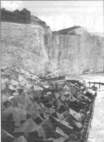
The brick wail just visible on the cliff-top marked the southern boundary of the old Splash Point Hotel; the hotel was demolished because of cliff erosion, but the wall survives. A number of sea defence ideas have been tried in the last half-century, one of the most successful being the 1961 positioning at the foot of the east cliff of what seemed like a senseless jumble of concrete tripod units. Over 40 years they have interlocked and today form a sturdy protective 'revetment' deflecting the waves from the cliff base. Just some of the strange devices that in the past have helped save us from the sea.
A number of devices have been used over the years to keep the sea at bay. One of the most successful has been this collection of interlocking concrete blocks. They were put in place 40 years ago at the toot of the east cliff and form a sturdy revetment, deflecting the waves from the base of the cliffs
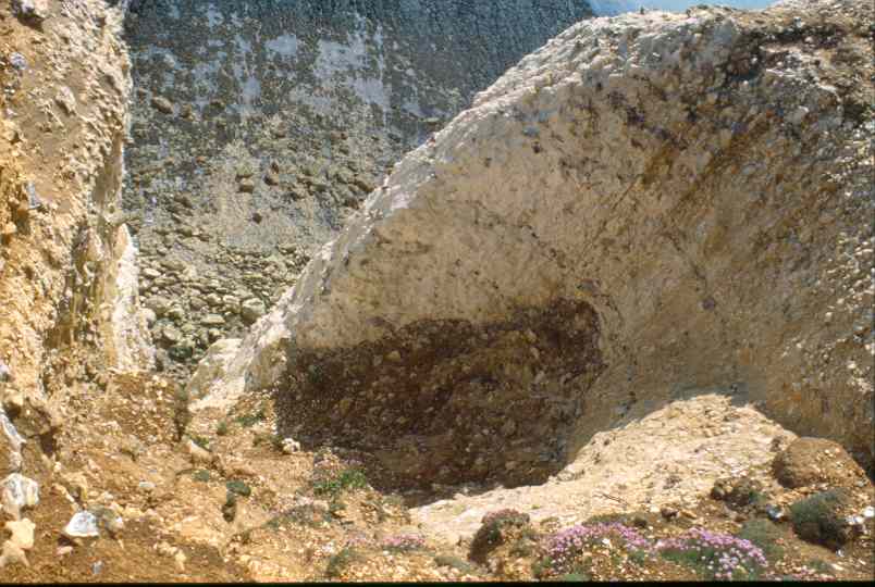
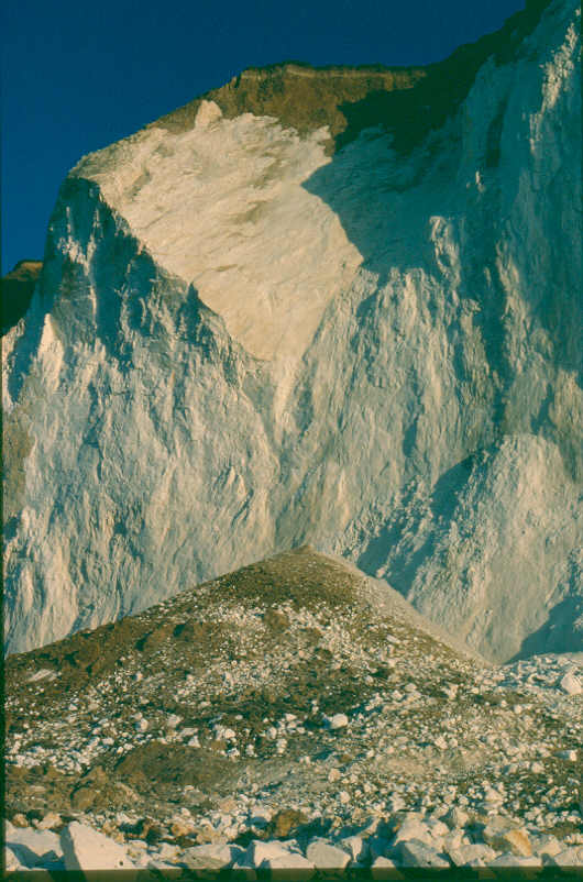
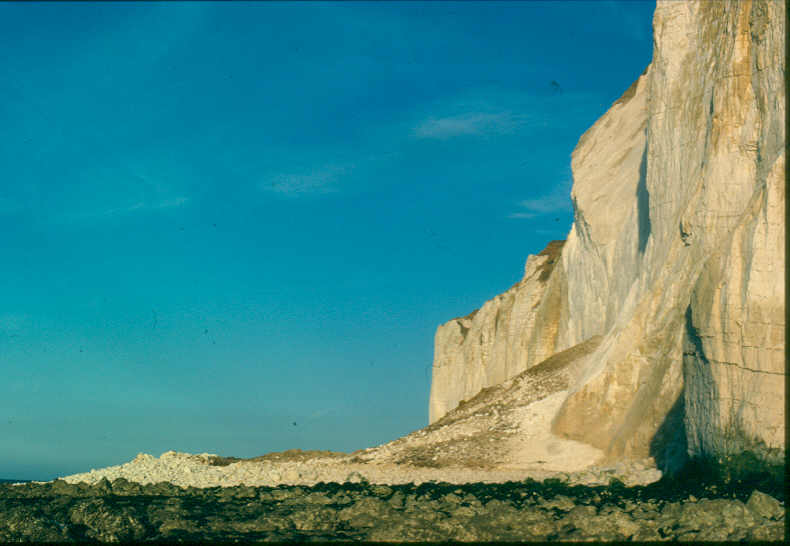
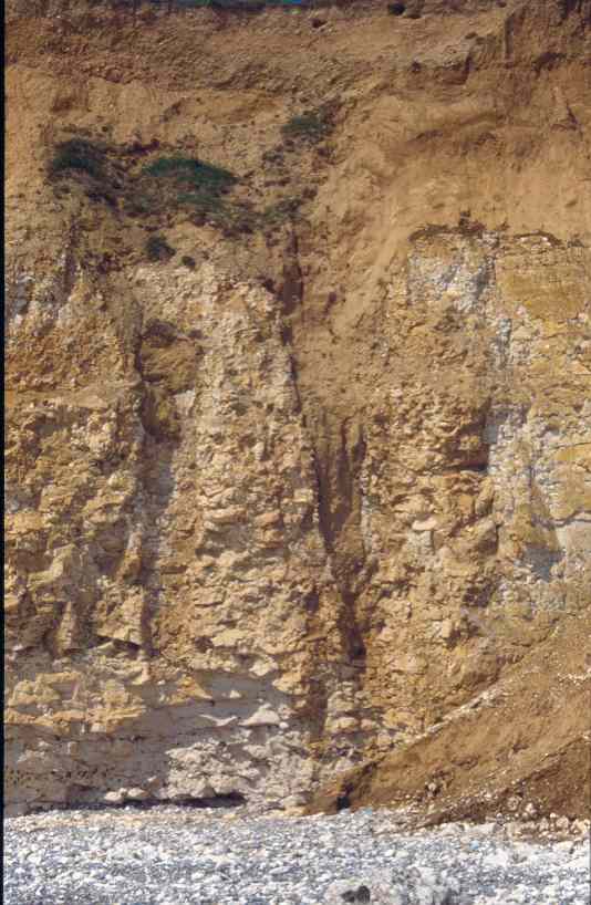
The following images show a cliff fall from Seaford Head on 2-July-1986 taken by D.A. Robinson. The second image shows clearly the fall to have originated from a wedge failure with the wedge being formed by intersecting joint sets.
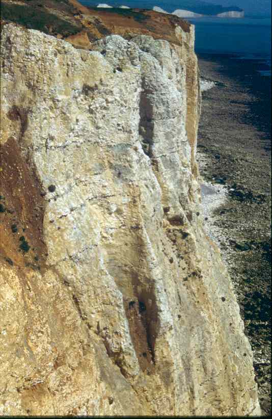
Chalk Dissolution Pipes
Along the cliffs between Seaford and Hope Gap solution pipes can be seen in cross section on the cliff face or in plan view on the shore platform. The highest density of these pipes can be found just east of Hope Gap in an area called Short Cliff. The sediments on top of the cliff are assumed to be deposited during the Wolstonian cold stage (200,000 to 130,000 B.P.). Water percolating through these beds became acidified and subjected the underlying Chalk to aggressive solution forming funnel-shaped pits and pipes. They can be identified by their shape, the relatively smooth walls and the infill of the sediment, though this infill may have been washed out when the pipes are exposed in the cliff. Some pipes have extended below present low water and have been 'decapitated' by cliff retreat leaving circular holes of ~1m in diameter on the shore platform. Some have a hardened rim of re-deposited limestone that make them look like wellheads. (more information can be found in Castleden, 1996)
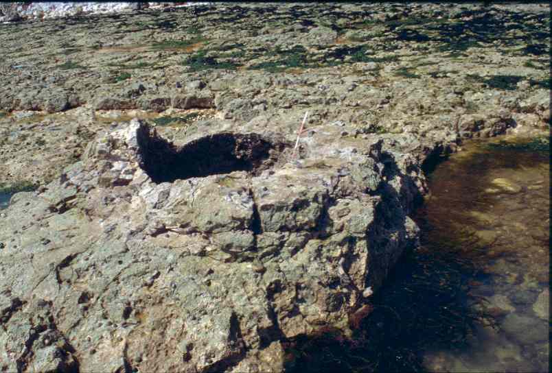
Two dissolution pipes, one almost empty of sediment, the other to the right still with sediment infill. The left hand pipe is undercut at the base to afford a view up the pipe (see next image).
View up the dissolution pipe in the previous image showing part of the circular outline of the pipe.
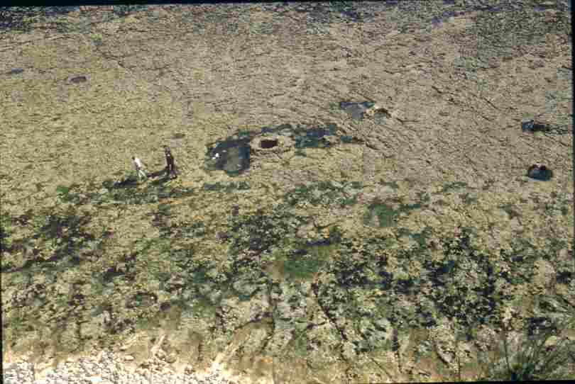
View from the cliff top onto the shore platform showing planview of four pipes. Persons left of the the pipe in the centre for scale.
This photo shows the hardened rim around the pipe in the centre of the previous image. Divisions on the yard-stick are at 10 cm intervals.
View along the cliff top showing sections of dissolution pipes.
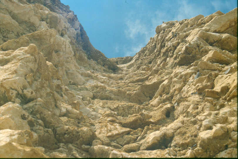
View into a dissolution pipe from the cliff top showing the funnel shaped upper part of a pipe.