CoastView - What happens offshore?

You may also want to know more about dredging related problems offshore and on-shore.


(All images and videos shown on this page originate from the GEOSYNTH-Project and were taken from the GEOSYNTH-CD-ROM located in Geography Resource Centre at the University of Sussex. GEOSYNTH was an INTERREG project involving Kent County Council, the British Geological Survey and the Bureau de recherches géologiques et minières)


General Topography


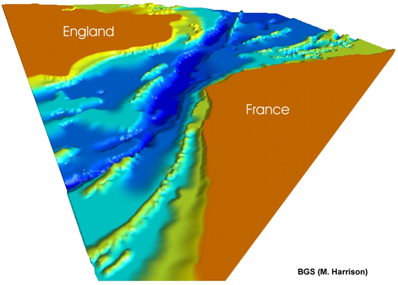
The Dover Strait forms the narrow link which joins the English Channel to the North Sea, and also lies on the boundary between the English landmass and the European continent. At its narrowest, the strait is 33km wide.
A major morphological feature of the Strait is the Lobourg Channel, which is a central depression about 6km wide. The trend of the channel axis is to the north north east (NNE) and cuts into the sea bed below the 15m bathymetric contour. The maximum depths within the Strait are found to the east of Le Colbart bank, where the depth is between 60 and 66m and to the north east of the Varne bank where depths reach 68m.
Sand banks are major features of the Dover Strait, ranging in width from 1 to several kilometres wide and up to 60km in length. An example of such a bank is the Bassure de Baas. These banks are generally asymmetrical in cross section, with their steep slope orientated towards the coast. This is particularly true for West-Dyck, Out-Ruytingen, Sandettié, Smal, Bassure de Baas and Vergoyer banks. On both sides of the Strait, the banks fan out towards the North Sea and the English Channel. In shallower coastal waters, the sand banks often overlap each other forming a complicated interconnected network. Examples of this are the banks of Flanders on the Belgian side of Calais.
The larger sand banks within the Straits of Dover tend to skirt the Lobourg Channel, which has the Vergoyer flanking its eastern side and Les Ridens, Bassurelle and Bullock Bank on its western side. In the northern part of the Dover Strait, South Galiper bank borders the western part of the Lobourg Channel whereas the rectilinear form of South Falls borders the channel to the east. Although other recilinear, straight banks, such as Le Colbart (The Ridge) and the Varne are present on the English side of the Strait there are no equivalent banks on the French side.
Within the Strait the banks generally lie on a relatively flat surface which slopes very gently from the coast. However, in some areas which are characterised by cliffed coastlines, and where the central channel approaches the coastal zone, slopes can exceed 20. With the exceptions of Berck and north east of Margate, lower coasts with dunes extend into the marine environment with an average slope of 0.20, with the sea bed reaching a depth of 10m some 5 or more miles (8km) from the coastline.
The Lobourg Channel passes near to the French coastline at Cap Gris-Nez and then trends north towards the English coastline east of Goodwin Sands. In this area, where the two coastlines are at their closest, the seabed slopes are relatively steep. Sand banks are more numerous to the north of Cap Gris- Nez and Dover with groups of banks formed in the Thames Estuary and Flanders east of Calais. Single, lone banks are found in the more open sea areas. The highest banks can be up to 25 metres high and can form dangerous obstructions for navigators.


Geological and other thematic maps of the Channel area can be found in the Geography Resource Centre at the University of Sussex.
The geology of the Channel is especially well known between Dover and Calais through investigations for the construction of the tunnel. Below is a geological map and profile of the tunnel area.


More related to coastal and fluvial processes is the quaternary geology. Below is a map of the bedrock bathymetry of the Channel. Note the channels incised into the bedrock that lead from the East Sussex coast into the channel that can be linked to todays river valleys.


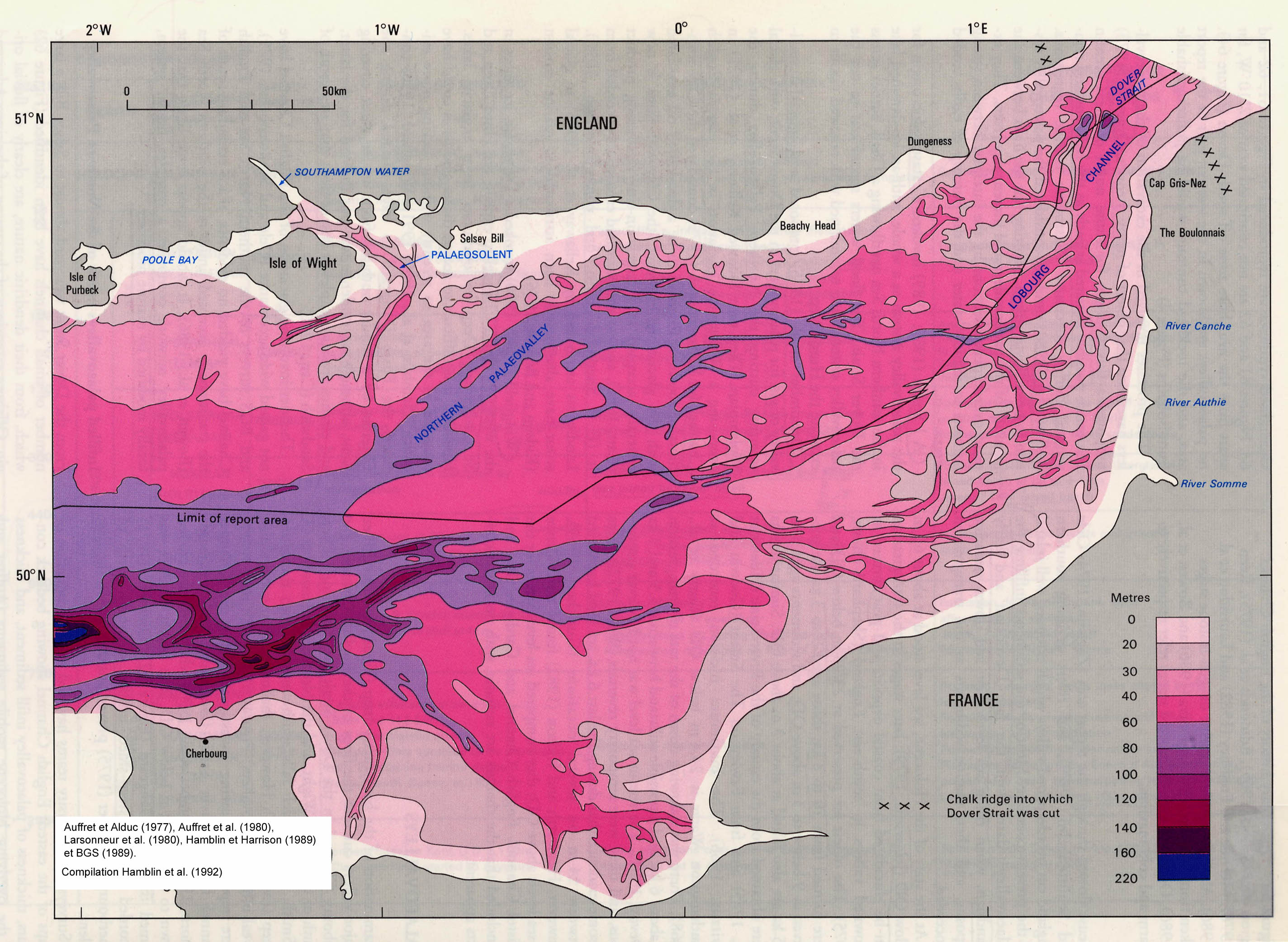
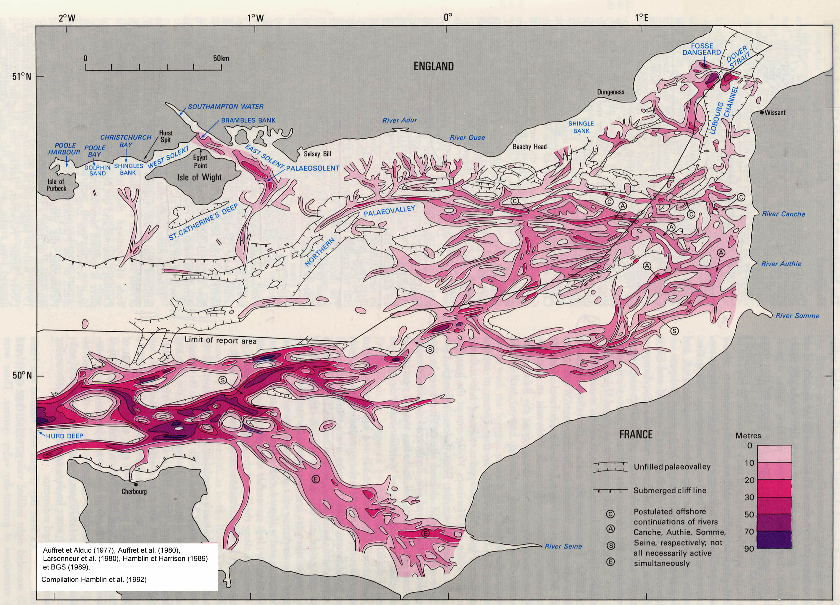
During Quaternary times there were a series of global climatic variations (oscillations) which comprised glacial periods characterised by the growth of polar ice caps, and interglacial periods characterised by the decay of polar ice caps. During glacial periods sea level fell to levels as low as –120 m below present day sea level as the polar ice caps and continental glaciers locked in enormous quantities of seawater. During interglacial periods sea level generally rose to present day levels. There may have been as many as 20 glacial –interglacial cycles during the 2 million or so years of the Quaternary when sea level rose and fell.
These cycles have greatly affected continental shelf areas over which the sea has repeatedly advanced and retreated. Marine and continental processes have shaped the seabed through cycles of erosion and deposition. These processes resulted in the formation on the continental shelf of large flat and gently dipping abrasion platforms that are commonly dissected by incised channels that may be open or filled with sediment.
Such features are well developed in the Straits of Dover. On both sides, wide and flat abrasion platforms may be observed on the seafloor and continuing beneath the sandbanks at water depths between 25 and 30 m. These platforms are connected to the shores by gentle slopes. The central part of the Straits is dissected by the Loubourg Channel, which is an open depression about 10 km wide with margins at water depths between 30 and 40 m. It connects the Southern North Sea and the English Channel. Numerous small channels have also been detected by seismics surveys and the thicknesses of the sediment infiling of these channels and below the mobile sediment (sandbanks or surficial cover) are shown on the Pleistocene map.
The infilled paleochannels form a network of valleys stretching out from the English and French coasts towards the axis of the Eastern English Channel and the Lobourg Channel. Although the precise nature and age of most of these infills are generally poorly known, they are believed to be dominated by fluvial deposits deposited during some of the major interglacial events of the Middle and Upper Pleistocene periods. These paleochannels form an extensive network in the whole of the Eastern English Channel. The Straits of Dover seabed is also dissected by more deeply incised depressions either parellel or transverse to the main paleovalley systems. In the central part of the Straits, the Fosse Dangeard is a complex elongate depression incised in soft Gault Clay down 170 metres below present sealevel. It is partly infilled by Pleistocene sand and reworked pebbles of chalk and flints.
The formation of the paleovalley system is clearly fluviatile in origin as demonstrated by their shapes and the geometry of their infill sediments. However, questions remain concerning the formation of the deepest elongated depressions such as the Fosse Dangeard. The base of these depresions are deeper than the lowest known sea levels during the Quaternary, processes other than fluvial erosion by rivers flowing across the shelf to low Quaternary seas must be envisioned. Many hypothesis have been proposed by various authors such as local current scouring by fluvial processes, high tidal currents, or a catastrophic event such as an outburst of water due to the breaking of a barrier at the front of the ice cap, dissolution of rocks and karst formation which are processes known to occur in present glacial conditions.
Many similar elongated and overdeepened incisions are also present in the North Sea and in East Anglia. The formation of these so-called ‘tunnel-valleys’ has been linked to scouring by water ciculation under ice-caps. If this hypothesis was invoked for the depressions in the Straits of Dover it would require southward extension of the ice during the later Quaternary glaciations beyond the current accepted limits for ice in the Southern North Sea. and Southern England. The evidence of glacial deposits on the floor of the Straits of Dover is limited to relict boulders believed to have been dropped by icebergs.
Important questions remain unresolved about the origin of some features. Although the Pleistocene evolution of the Straits of Dover was dominated by subaerial and submarine processes associated with the major glacial and interglacial cycles, the most significant event was the breaching the chalk barrier between the North Sea and the English Channel when the Straits of Dover came in existence. The timing of this breakthrough is believed to be about 500,000 years B.P.

Bedforms of the Channel floor


Click on the map of bedforms on the channel floor to see the legend.


The formation of the different sedimentary features depends on current strength and sand availability (Belderson et al., 1982). With increasing currents, the following series of bedforms is observed: megaripples, sand waves, sand banks, sand ribbons and finally sand streams. If the sand supply decreases, sand banks will be cannibalised to form sand ribbons and sand streams, sand patches replace fields of megaripples and the other types of bedforms will appear less frequently.
They can be seen in side scan sonar images ("under water air photographs") or in sonar profiles (see below).


Videos

Click on the images to start the associated videos. The videos were taken on the Channel floor from a manned submarine during explorations for the Channel Tunnel (you hear the original comments in French).
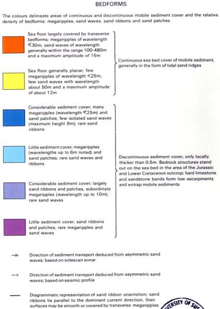
The video shows the channel floor in the vicinity of an outcrop of chalk bedrock .These outcrops are covered in places by thin veneers of sediment, in this case sand and gravel.
This video show a typical cover of sand and gravel on the Channel floor.
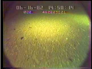
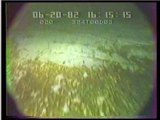
In this video sand particles can be seen moving from right to left across the crest of a sand wave on the Channel floor.
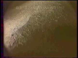