

General SettingThis research is being done as part of IMS involvement in the European Union MAST 3 INlet Dynamics Initiative: Algarve (INDIA) project. The field site of the project is the Barra Nova tidal inlet located within the Ria Formosa barrier-island system in the Algarve, southern Portugal. The inlet seperates the Ancão Penisula from Ilha da Barreta at the western end of the Ria Formosa system. This part of the Ria Formosa is one of the most dynamic areas in the system. The Barra Nova inlet was opened artificially in June 1997 and after a relatively rapid naturalisation process the inlet is now a highly dynamic natural tidal inlet with well developed ebb and flood deltas. The Ria Formosa region is mesotidal, it has a tidal range between 1 and 4 m, and has a low to moderate wave climate with intermittent storm events. |
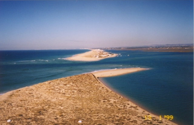 A photo of the Barra Nova inlet system from the top of the video tower, approximating the view of the inlet camera. |
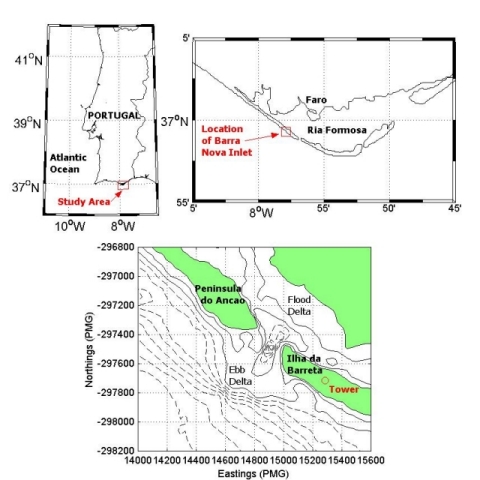 Maps showing the location of the INDIA field site. | |
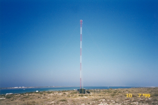 A photo of the video tower site on Ilha da Barreta. |
Camera System Set-upA video camera system was deployed by IMS at this field site to monitor the inlet and the adjacent ebb delta. The video system consisted of two fixed black and white video cameras mounted on a 30m tower located on Ilha da Barreta, on the western side of the inlet. The cameras were controlled via a PC on which the images were also stored and the system is entirely self sufficient with power requirements supplied by batteries charged by a solar panel array. The system began taking images on the 25 November 1998, and continued to take images until 13 January 2000. |
Oblique Camera ImagesThe two cameras (inlet and delta) took simultaneous snapshots on the hour every hour during daylight. In addition both cameras took a ten minute time exposure every hour starting on the hour. These time exposures are an average of images taken each second over a ten minute period and are used to estimate subaerial bathymetry and sand bar position. Images taken by the inlet camera show the morphological features of the inlet along with the surf zone on the Praia de Faro, Ancão Peninsula, side of the inlet. Images taken from the delta camera show both the delta morphology as well as the surf zone of the delta. | |
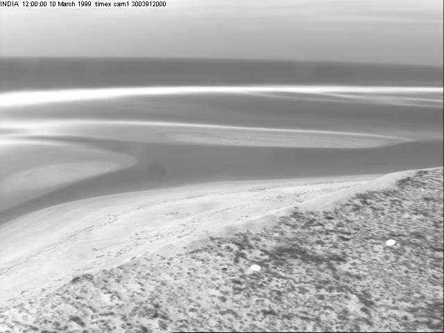 An example of an hourly ten minute time exposure image from the delta video camera. |
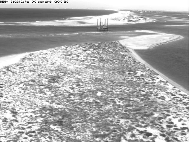 An example of an hourly snapshot image from the inlet video camera. |
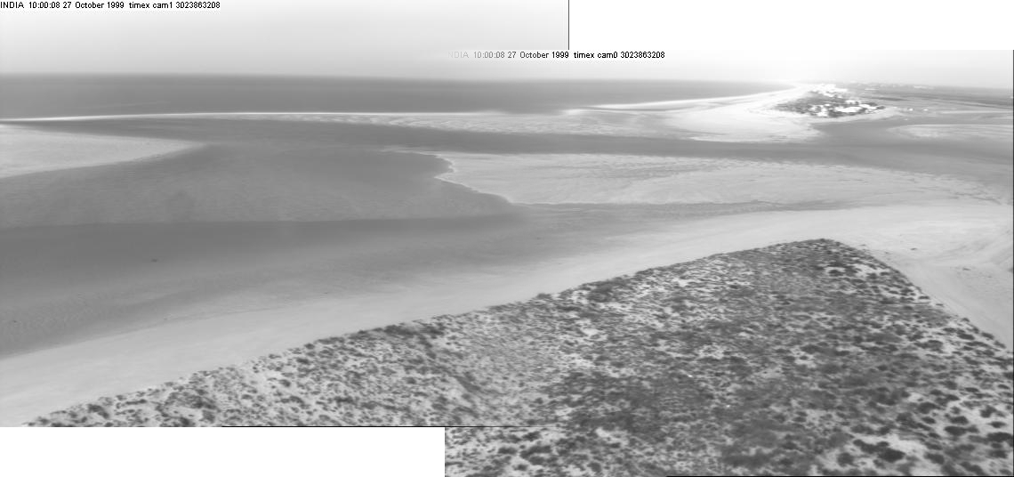 A composite image showing the field of view from both cameras. | |
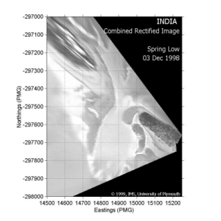
Rectified ImagesThe images are rectified, translated from image co-ordinates to real world co-ordinates, by means of photogrammetry. This is achieved by using both Ground Control Points (GCP's) and the position of the cameras that were surveyed on the Portuguese Melrica Grid (PMG). By rectifying the images from both cameras using the same bounding box and then normalising and combining the rectified images a plan view of the inlet and ebb-shoal delta is obtained. | |
 |
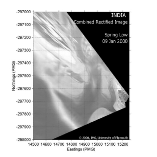 |
| Combined Rectified Images of the inlet system at Spring Low tide on 3rd December 1998 (left) and 9th January 2000 (right). | |
Movies |
|
 |
 |
| A movie of the evolution of the inlet system
over the period December 1998 to October 1999 made with time
exposure camera shots from the inlet camera. |
Another version of the
evolution of the inlet using Combined Rectified Images to make the
movie. |
FundingThe site in Faro was funded by: | |
 |
The Institute of Marine
Studies University of Plymouth Drake Circus, Plymouth, Devon PL4 8AA, United Kingdom Tel: +44 (0) 1752 232 458, Fax : + 44 (0) 1752 232 406 Contacts: Dr Mark Davidson (mdavidson@plymouth.ac.uk) Mr Brad Morris (bdmorris@plymouth.ac.uk) Web page: http://www.plymouth.ac.uk/ |
| |
European Commission's Marine Science and
Technology Research Program Under the INDIA Project: INlet Dynamics Initiative: Algarve Contract: MASTIII, MAST3-CT97-0106 Started in November 1997 for three years Web Page: http://www.pol.ac.uk/india/INDIA.html |
 |
Naval International Cooperative
Opportunities in Science and Technology Program
(NICOP) Intermediate Scale Coastal Behaviour: Measurement, Modelling And Prediction Award: N00014-97-1-0792 University of Plymouth Drake Circus, Plymouth, Devon PL4 8AA, United Kingdom Tel: +44 (0) 1752 232 458, Fax : + 44 (0) 1752 232 406 Contact: Prof. David Huntley (dhuntley@plymouth.ac.uk) Web page: http://www.onr.navy.mil/ |
CollaborationWork on data from the site in Faro is also in collaboration with: | |
 |
Coastal Imaging Lab College of Oceanography and Atmospheres Sciences Oregon State University 104 Ocean Admin Building Corvallis, OR 97331, United States of America United States of America Contact: Prof Rob Holman (holman@OCE.ORST.EDU) Web page: http://cil-www.oce.orst.edu:8080/ |
| Centro de Investigação dos Ambientes
Costeiros e Marinhos (CIACOMAR) Universidade do Algarve Avenida das Forças Armadas, 8700-311 Olhão, Algarve, Portugal. Contact: Prof. J M Alveirinho Dias (jdias@ualg.pt) Web page: http://www.ualg.pt/ciacomar/ |
 |
Centre for Coastal & Marine
Science Proudman Oceanographic Laboratory Bidston Observatory, Bidston Hill, Bidston, Prenton, CH43 7RA, United Kingdom. Contact: Dr. Jon Williams (jjw@ccms.ac.uk) Web page: http://www.pol.ac.uk/ |